It's Peach Days in the town of Hurricane, Utah and time once again for the annual Hurricane Canal hike. This year I thought I'd go along and get all the history of the canals even though I had hiked parts of the canal on a couple of different occasions with Jeff Frost and Dan Lackey.
We met at Hurricane Heritage park at 6:30am, went over a few things, and then each drove to drop off our cars where the trail ends at the radio tower. To get there, we took 100 south in Hurricane, which turns in to hwy 59, east up the Hurricane Cliffs. Just before we got to the top, there is a turn off on the left hand side of the road with a big dirt parking lot and a radio tower.
The 20, or so, of us that were doing the hike left our cars here and piled into 4 high clearance vehicles that took us to the trail head. We continued up hwy 59 for about another three miles and took a left at another turn out with a well graded dirt road, called Sheep's Bridge Road. Once over the cattle guard, we traveled for about 2 miles on the well maintained road until a single track came in from the left.
It was unmarked and was just wide enough for 1 car to go through. A passenger car might be able to make it on this road depending on the conditions (no rain for a while) but a high clearance vehicle would make it much easier.
After a very short time on this road - maybe a third of a mile - the road splits again and the right fork is signed "Virgin Dam." We took this fork for about a mile and made it to the trail head, which is where the road ends. There is a bathroom and a sign at the trail head.
We signed the register and started on our way at 7:30 before the sun had come up. After a few hundred yards the trail splits. One portion heads straight while the other breaks off to the right and heads down hill. There is a sign marking the way to the canal as being on the portion that descends off to the right.
We were told that the first portion of the trail was constructed about 12 years ago by AmeriCorps. It descends down from the parking area to the Hurricane Canal about 300 feet below. The grade is moderate and the trail well maintained despite several floods that have at one time or another washed out parts of it.
Once down to the Canal, the trail either stays on the ditch riders path or in the canal it's self the rest of the way. Many signs along the way give a brief history of the different portions of the hike. There are 12 caves that the canal goes through, though we only hiked/stooped/crawled through about 8 of them.
At one point, a gate had been put up because an engineer had deemed that one of the caves wasn't as structurally sound as it should be and an alternate route down to the canyon floor and back up to the canal was created. Our guides explained this to us and gave us the option as to which route to take. We all opted to go the way of the original canal.
This portion takes you to a place which has been given the name "China Town" perhaps because of the camps that were set up there by many of the canal workers in the 1890's and early 1900's or perhaps because of the Chinese immigrants that helped teach the locals how to blow holes through the rock with explosives for the canal to get through.
At one time a rock slide completely took out the canal and all the cliff around it. It has been replaced with a 30 foot long large piped section which must be hiked on to continue on the hike. For those extremely fearful of heights, this might make them turn around and take the "approved" route, but all 20 of us made it across, one at a time, and then immediately through a small cave where we encountered a surprised bat.
Immediately after this obstacle, we were met with the China Town bridge. It is an amazing structure for it's time, constructed by a people with not much money. It took the canal from one side of the canyon to the other. In rainy times, a water fall flows from the cliff tops high above and brings with it sediment that has built up in the canal.
We crossed the canal bridge and continued on our way. We noticed the LaVerkin Canal across the canyon from us and spotted an old fireplace and campsite used by the people who constructed the canal.
Another gate crosses the canal with a sign attached indicating that the trail climbs up the hill at that point. I have been up that trail before and it is a steep, poorly maintained trail. Fortunately our guides had us continue around the gate and on the canal. Soon we saw the Pah Tempe hot springs far below with a few people enjoying the natural hot springs. The canal goes right over the hot springs and I looked down and saw many buildings that make up the resort.
We also could see the large Virgin River Bridge that SR-9 crosses to get to the town of LaVerkin. Not long after the hot springs and spotting the bridge, the trail makes it's way out of the canal and up a draw on the left. The trail in this spot is faint and easy to miss so an identifiable landmark to look for is large black rock formations. They make up the far side of the draw. From here, we climbed about 200 vertical feet up to another faint old wagon road. From this point, i spotted the top of the radio tower where we left our cars.
The hike registered 4.48 miles on my GPS, though I was in and out of service. I was told that the hike would be about 5.7 miles. We got back to the cars at 10:25. An hour of our total time was used learning about the history of the canal and taking in the beautiful surroundings.
History:
Construction started on the Hurricane Canal in 1893. Three known engineers said that the canal would be impossible to build but two early settlers - John Steele and James Jepson - took it upon themselves to see that it became a reality. In all, construction took 11 years but on August 6, 1904 water flowed to the Hurricane Valley through the canal for the first time.
All work was done by hand with only simple tools - picks, shovels, crowbars, and a homemade wheelbarrow. When the canal reached a spot where a tunnel was necessary, the workers would skip that portion since they had no explosives and continue the canal on the other side, having faith that they would be provided the means to get through the rock. The canal was to be 8 feet wide with the water running 4 feet deep.
With no way to purchase the explosives or many of the materials needed to complete the canal, James Jepson went to Salt Lake City and convinced the LDS Church to purchase $5000 worth of canal stock. With new funds and the influx of Nevada and Silver Reef miners who were experts in tunneling but looking for work due to the Panic of 1893, the canal was finally completed.
Once completed, workers known as ditch riders would ride on a trail daily that was made with the displaced dirt and rocks from digging the canal to make sure there were no washouts or leaks. During heavy rains, they would ride the canal many times a day, opening diversions in the canal when necessary to let out water to keep the canal intact. Too heavy of a water flow would erode and eventually break through the walls of the canal which were made entirely of dirt and rock.
In 1951, cement was finally used to repair and reinforce the trouble spots in the canal. When massive boulders would fall from above and land in the canal, the ditch riders would build fires to heat the rock and then poor cold water from the Virgin River on top to create fissures that they could get tools into to break down the boulder into smaller, manageable sizes.
The building of the Hurricane Canal was a huge, miraculous undertaking that has allowed Hurricane to blossom into the wonderful town it is today.

The bathroom and sign indicating the trail head
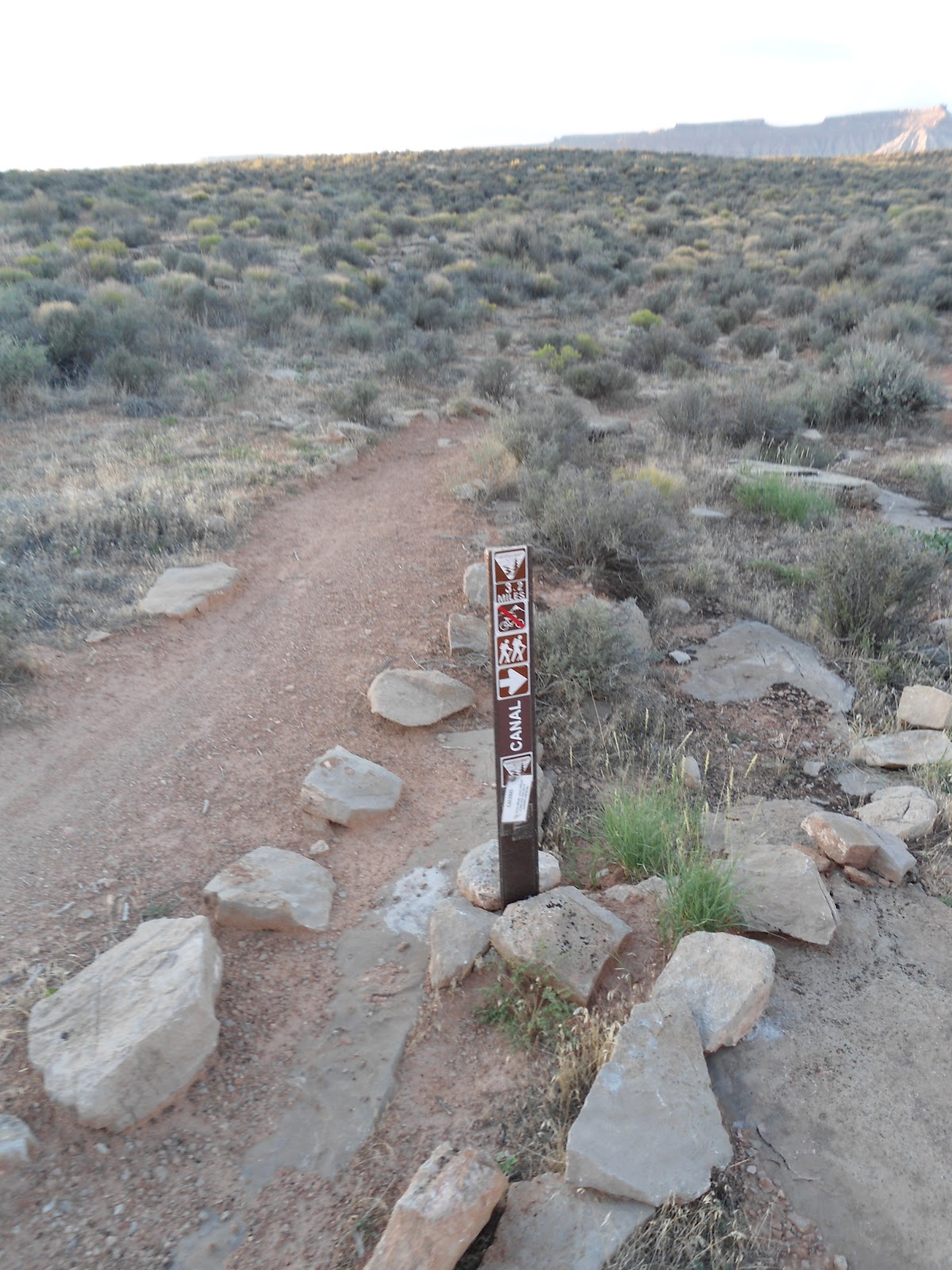
Where the trail splits. The main trail you see on the left continues on along the rim. The trail down to the canal goes off to the right as indicated by the arrow on the sign.

A look at the diversion dam (in the distance) built in the 1985 as part of the Quail Lake pipeline project.

Down at the place where the canal waters left the Virgin River. If you look closely, on the bottom left of this picture you can see remnants of the original dam built in 1912.

This is a picture of the original Ditch Riders trail which is also the trail we used - some 110 years after it was built - for our hike. The canal is on the left.

One of the caves we came out of.

A look down at the Virgin River from the trail.

If you look closely, you can see a fireplace that was used by the workers who constructed the canal.

One of the water diversions that the ditch riders would open in times of extreme high water. This would take pressure off of the canal and allow water to flow out of the canal back into the Virgin River.

A section of the canal that was completely destroyed by a landslide. This pipe was used as a replacement for the water to go through.

The China Town bridge.

Right in the center of this picture is the shack built in 1902 to house the explosive powder they used to blow holes through the rock to make tunnels.

The pools of the Pah Tempe hot springs below.

One of the last caves to pass through before the hike out.


No comments:
Post a Comment