It had been a week since our bushwhack through what turned out to be Long Hollow in the Ashdown Gorge Wilderness and Liz and I wanted to get another look at the area so we decided to try the Rattlesnake Creek Trail.
 |
| The turnout where you leave the pickup vehicle |
Two cars are needed for the Rattlesnake Creek trail hike. The first car is left at a small parking area off the left side of hwy 14, about 7 miles up the canyon from Cedar City. It is very easy to miss. The pullout is immediately before the construction to repair the landslide that closed hwy 14 for a year.
After leaving our first car here, we loaded into our other vehicle and continued up the canyon. At the Hwy 148 junction, we took a left and headed through Cedar Breaks National Monument. The Rattlesnake Creek trail head is just on the outside of the North boundary, exactly 20 miles from where we left the first car. There is a parking area and signs marking the trail head.
 |
| Rattlesnake Creek trail head |
The elevation at the trail head is about 10470 feet. There was still a little chill in the air when we started on the trail at 10:18. The trail starts by following the National Monument boundary fence over open terrain until dropping slightly through pine and aspen forests. After about a half mile, a trail comes in from the left that, if followed, will go for about 50 yards to a great overlook of Cedar Breaks. Another similar lookout trail connects to the main trail a quarter mile further. We took the side trails to take in the view and then continued on our way.
After about a mile, the trail turned south across a mountain side giving us a spectacular view of where we would be going. We could see the canyon formed by Rattlesnake Creek and where in joined the Ashdown Creek wash. From here the trail heads back through a forested area before getting to Stud Flat after 2.9 miles from the trail head.
 |
| Stud Hollow |
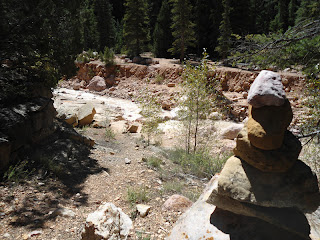
Stud Flat is an expansive open meadow that descends gradually toward Rattlesnake Creek. The top of Stud Flat provides beautiful views of the surrounding landscape from forested mountains to deep river gorges to open meadows. There are cairns throughout the meadow but the trail was well enough worn that we didn't need the cairns to help us find our way.
 |
| Crossing Rattlesnake Creek |
From Stud Flat, the trail starts a steep decent down to Rattlesnake Creek via some switchbacks. At first the trail parallels the creek from above on the east side until it drops down the rest of the way and crosses the creek at 4.3 miles from the trail head. After crossing Rattlesnake Creek, the trail stays on the west bank about 30 feet above it. As we hiked on the west side, we came within about 15 feet of a surprised deer which apparently didn't hear us coming. It spotted us and ran off into the forest.
 |
| The junction with the high mountain trail. |
We actually lost the trail about a mile after crossing the creek because we had stayed too low. We climbed straight up the steep hillside and found it again and continued on our way. Just .3 miles after losing the trail, and 1.3 after crossing Rattlesnake Creek, the High Mountain trail comes in from the right. We were greeted by the back of a sign indicating the junction of the two trails. At the junction, the trail crosses Rattlesnake Creek again just above a pretty 5 foot waterfall before climbing out of the Rattlesnake Creek canyon.
 |
| The spot where we enter Ashdown Creek. |
After climbing out of the canyon, the trail parallels it for a little while before turning back east and climbing over a ridge to the Ashdown Creek canyon. The views into the canyon from above are awesome and I saw many spots that I was looking forward to checking out once I got down in the canyon. The trail was heading back up the canyon towards Cedar Breaks, taking us to a place where we could enter into the wash. Finally after 6.64 miles from the trail head, we were able to enter the Ashdown Canyon.
I had planned on trying to locate the Potato Hollow trail that continues out of the Ashdown Creek on the other side but was so excited and taken back by the beauty of the creek and canyon, I forgot to. Unlike Rattlesnake Creek which runs clear, Ashdown Creek was a bit silty, matching the color of the rocks around it. From here on, it's a water hike, much like the Narrows of Zion Canyon.
 |
| Looking out from inside of the Grotto |
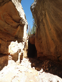
A short time after entering the Creek (not sure about the mileage from this point on because my GPS was without satellite reception for much of the rest of the way), we came to an amazing grotto that we had spotted from the trail high above before dropping into the canyon. The grotto is the highlight of the hike. As I walked over to check it out, I felt like for a moment I was on another planet. The magnitude of the walls and the great force of the water it took over thousands of years to create it was mind numbing. We took out some snacks and took in the beauty.
 |
| Tom's Head |
After enjoying the moment for a while, we continued on our way down the river to our next point of interest, the confluence of Rattlesnake Creek with Ashdown Creek. I had read about the beautiful waterfall in Rattlesnake Creek and wanted to see this impassible object that made us have to leave Rattlesnake Creek, go all the way over the draw, and down into Ashdown wash to get around it.
 |
| Lake Creek waterfall |
After winding our way through the Ashdown Gorge for a little short of a mile, we came to Tom's Head - the familiar land mark rock formation that marks the confluence of Rattlesnake and Ashdown Creeks. It was fun to see the clear water from Rattlesnake Creek that I had just been hiking in a short time before. There are actually 2 waterfalls to see - the one from Rattlesnake Creek and also one from Lake Creek, which joins Rattlesnake Creek. The trip up to the confluence of Lake and Rattlesnake Creeks is only .6 miles (although it seems longer than that with the anticipation of seeing the waterfalls. There is also a mini waterfall of about 8 feet about half way to get to the waterfalls that is bypassed by taking a somewhat rickety but stable ladder that was made with tree trunks and boards.
 |
| Rattlesnake Creek waterfall |
From the Lake and Rattlesnake Creek confluence, it is only a 200 yard walk to get to each of the waterfalls. The creek entering from the left is Lake Creek, which waterfall is very unique as it passes underneath massive choke stones high above which create a neat alcove of sorts. The creek on the right is Rattlesnake Creek which has a minor obstacle to get passed before getting to the actual falls. The obstacle is just an awkward climb up 3 foot rocks that requires you to stand in knee deep water to get to the base of them. The falls are magnificent and the small slot canyon of Rattlesnake Creek is worth the side trip it's self.
At this point I should mention that it was fun to notice the height of the canyon walls around us from time to time as they started out at just a few feet and by the end of the hike were about 600 feet above us. Below the confluence of Rattlesnake Creek, Ashdown Creek continues meandering through the canyon. Here and there, remnants of debris washed down during flash flooding gave me pause and encouraged an occasional scan of the sky for rain clouds.
 |
| Flanagan's Arch |
After leaving Tom's head by Rattlesnake Creek we continued downstream until we located Flanagan's Arch high above on the north (right) wall. It was probably only a half mile to a mile below Tom's Head, but seemed farther than that. If you're not looking for it, it's easy to miss. It's at a point where the south canyon wall recedes back, and the river course widens. On the south side is a large boulder which has some black coloration to it. To see the arch, you have to be on the south river bank. There is a large cairn on the south bank to mark the spot, but if you're hiking with your head down through the river, you will miss it.
Just around the bend from Flanagan's Arch, we saw the spot where we had joined the Ashdown Creek a week prior during our Long Hollow bushwhack adventure. Soon we saw the highway off in the distance and were forced to scramble through knocked down trees, mud, boulders, and sink holes to get past the landslide that covered the trail a couple of years back. This scramble is by far the least enjoyable part of the hike.
Once to the man-made coverts, the trail heads up on the right side and follows and old overgrown jeep trail back to where you've left your first vehicle. We made it back to the car at 5:24 after seven hours and six minutes and about 12 miles of hiking.
 |
| The start of the Rattlesnake Creek trail |
 |
| A Look down into Cedar Breaks National Monument from one of the lookout points |
 |
| Cedar Breaks National Monument |
 |
| A view of Rattlesnake Canyon and Ashdown Canyon in the distance from the trail. |
 |
| The trail as it transitioned from meadow to forest. |
 |
| Just after crossing Rattlesnake Creek, the trail paralleled it to the right. |
 |
| The front of the sign marking the junction of the High Mountain Trail. |
 |
| Where you cross Rattlesnake Creek the second time before heading over to Ashdown Gorge. |
 |
| The trail as it heads to Ashdown Gorge |
 |
| The view of Ashdown Creek from the trail above before it descends down to it. |
 |
| A cairn marking the spot where you enter Ashdown Gorge. |
 |
| The entrance to the grotto |
 |
| The mini waterfall up Rattlesnake Creek. |
 |
| A view of Lake falls from a distance. You can see the front big choke stone. |
 |
| Underneath the waterfall looking up at the three choke stones. The front stone is to the left. |
 |
| A look at the back of the alcove created by the waterfall. |
 |
| The last few steps before seeing the Rattlesnake Creek waterfall. |
 |
| The last obstacle before the falls. Easy to climb up, just awkward. |
 |
| The Rattlesnake Creek falls. |
 |
| The side of the canyon walls on the way out of the Rattlesnake Creek Canyon. |
 |
| Liz coming back down the ladder. |
 |
| Ashdown Gorge |
 |
| A little boulder hopping...er...bum sliding... |
 |
| Debris from a flash flood. |
 |
| This is a picture of the parking area where the first car is left. Notice the gate in the background. |


This is one beautiful place you must see! It's nature at its best!
ReplyDeleteBrian Head Utah