Although most of my posts are devoted to my many hiking adventures, I recently had the opportunity to scout out the Lava Point Campground as I am contemplating using it for the
trans-Zion hike.
Basic Information:
There are 6 campsites located in a circular fashion around a dirt road available on a first-come, first-served basis. There is no charge to camp. There are nice pit toilets and trash cans, but no water. Because of the high elevation (7,850 feet) Lava Point sees a significant amount of snow in the winter months and can be a chilly place to camp in the Spring and Fall. In fact, because of the poor road conditions as the weather turns cold, it is generally only open May through September.
 |
| The information board and campground registration. As of 2016, there is no fee to camp here! |
 |
| This was about as good of a picture as I could get of the campground layout. |
 |
| A look at the facilities. They are located at the entrance to the campground, closest to sites #1 and #6. |
 |
| Here's a shot of site #1 as seen from the road. The road continues on to the left. The dirt you see in this picture is a spot to park your car if driving to this campsite. All the sites are similar in size. |
 |
| Each has a fire pit and a picnic table... |
 |
| ...a nice space for a tent... |
 |
| ...and a bear-proof trash receptacle. |
Getting There:
The Campground can be accessed via the Kolob Terrace Road, located just on the east side of the town of Virgin, Utah. To get there, head north up the Kolob Terrace road from SR9 for about 25 miles until you see a signed dirt road off to the right indicating that Zion National Park and the Lava Point Campground is 1.8 miles down that road. One last point of interest is that once you are near the Lava Point Campground, you will encounter one last fork in the road. A sign indicates that the campground is off to the right, while the West Rim Trailhead is off to the left.
 |
| The SR9, Kolob Terrace Road junction, just to the east of the little town of Virgin. |
 |
| Here's a look at the turn off onto the dirt road from the Kolob Terrace road. From here it's 1.8 miles to the Lava Point Campground. |
 |
| And here's a look down the dirt road toward the campground. |
 |
| A look at the last fork in the road before the Campground. |
Camping at Lava Point as part of the Trans-Zion hike.
The good news is that no permit or fees are required to hike the Trans-Zion hike if you camp in Lava Point. If you choose to camp in one of the other back country camp sites, both are required. The bad news is that camping at the Lava Point Campground adds about 2 miles to the total hike (it's already 38 miles...). That's because the campground is about a mile from the Wildcat Canyon trail which is the trail you are on when you break off for Lava Point. There is also 330 feet extra elevation gain and loss going back and forth from the trail to the campground.
To get to the Lava Point Campground from the Wildcat Canyon Trail, head uphill from the West Rim Trail parking area for about .7 of a mile on a dirt road until you reach a small marked trail (Barney's Trail) on the left hand side of the road that reads, "Barney's Trail. Lava Point Campground .3 mile."This small trail heads uphill through dense vegetation until it comes out at camp site #2 in the Lava Point Campground after .3 miles. Obviously to get back to the Trans-Zion hike the next morning after camping at Lava Point, just retrace your steps.
 |
| Here's a picture of the West Rim Trailhead next to the parking area. The elevation here is 7,520 feet and GPS coordinates are N 37°22.758 W 113°01.399 |
 |
| After hiking about .7 miles on the dirt road from the West Rim Trailhead parking area, this is the small sign that marks "Barney's Trail" that takes you directly to Lava Point. It should be noted that you can also take the road to the campground but it will tack on about another mile. The elevation here is 7,633 and the GPS coordinates are N 37°23.181 W 113°01.784 |
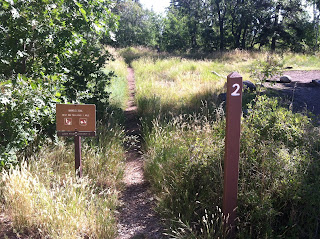 |
| And here's a look at where Barney's Trail enters the Lava Point Campground - right next to camp site #2. Elevation here is 7,850 feet and the GPS coordinates are N 37°23.037 W 113°01.960. |


No comments:
Post a Comment