Thursday, October 25, 2012

Confluence View and Tortoise Track, Confluence Park

25 Oct 2012

With the days getting shorter and hiking season nearing an end, I knew I wanted to go on another hike, but it would have to be a short one. I decided on Confluence Park in Hurricane.

Confluence Park is a 344 acre unmaintained park managed by Washington County and contains 10 different hiking trails. Some trails are as short as .3 of a mile and some as long as 2 miles. Of course, you can combine multiple trails and make a longer hike if desired. Within the park, the Ash Creek and La Verkin Creek drain into the Virgin River.

There are a number of different trail heads. I have always gone to the trail head at the end of 200 West in hurricane. To get there, go north on 200 West off of State Street and take the road until it ends. The last few hundred yards are on a well maintained dirt road past a few homes on the right. There will be a place to park your car by pulling off to the side of the road.

The fence marking confluence park
Liz and I started our hike down the dirt road about 10:55. Shortly we came to a small fence that marks the beginning of Confluence Park. This hike has always been a favorite hike of my kids, ages 6, 5 and 3, although they hiked it also when they were much younger with me. Liz and I were going to do a slight variation of the hike I normally take my kids on.

The normal route which starts from the parking area at the end of 200 West is on a trail called Tortoise Track. It gets it's name because it finishes by the desert tortoise preserve. The last time my kids and I were down there last summer, a worker was in the preserve (an open area surrounded by barbed wire fences) feeding and watering the tortoises. He let my kids and I come it and view the tortoises up close. It was a great experience for my kids.

This is the intersection where the Confluence View trail intersects the Tortoise Track trail.
The Tortoise Track heads straight while the Confluence View turns off to the left.
Instead of taking Tortoise Track on the way down, Liz and I decided that we would take the Confluence View trail. The Confluence View Trail intersects the Tortoise Track trail, but actually starts at the end of Main Street in Hurricane. That trail head is marked with a plaque that has some interesting information about the scouting out of the area by Parley P Pratt to see if it was suitable for settlement.

The Confluence View Trail intersects Tortoise Track just a few hundred yards past the fence and it is a faint old jeep road where it crosses. We took a left and went down hill towards the Virgin River. The Confluence View trail winds down under the cliffs we had just been on. The cliffs over head cast a shadow on the trail and both Liz and I were anxious to get back to the sunlight to warm up a bit.

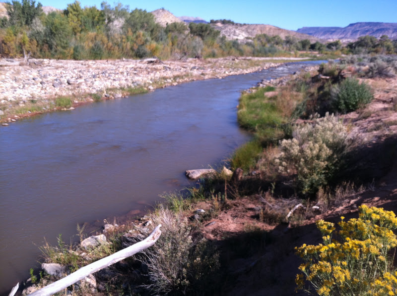
The Virgin River from the trail.
Once the trail makes it down to the river, it intersects the Virgin River Trail, which is marked by a trail sign with no name. We headed up stream on the trail until we got to the normal spot where we take the kids to play in the river. At this point, the fence to the desert tortoise preserve is visible. Liz and I spotted 3 tortoises that had come out of their tunnels to sun themselves.

Once past the desert tortoise preserve, the trail splits and the one that heads up the hill (and back to the car) is the Tortoise Track trail. We headed back up the hill and made it to our car at 11:55. Our total hike was abut 1.3 miles. This will be a fun area to explore further.
The view at the start of the hike.

Thursday, October 18, 2012

The Watchman, Zion National Park

18 October 2012

I was in the mood for an easy hike so I thought I would try The Watchman again. The Watchman was the very first hike I ever went on in Zion National Park about 15 years ago. I had forgotten a little what it was like, so I thought I better make it's acquaintance again.

Liz and I got to Zion National Park about 11:00, got our passports stamped and got on our way about 11:15. The trail head starts just across the bridge that leads to parking and the visitor's center, and is signed from the road. We parked in the dirt parking lot because the trail runs along the west side of it which makes it easier to access.

After just a quarter of a mile, the trail crosses a service road and starts the ascent to get to the look out point. The trail is extremely well maintained and is easy to follow, much of it covering man made stairs and flattened ground. In fact, we passed 6 park rangers maintaining the trail on our way up.

As the trail ascends, it follows the north side of a side canyon, until it wraps around to the south side and continues up to the look out point. We spent a few minutes at the top taking in the beauty and getting a neat birds eye view of the layout of the visitors center, movie theater, museum, and lodging for the National Park staff. It is really the best view of the layout from above of any of the hikes I've been on in the park.

We made it back down to the car at 12:45 after 3.13 miles. (The trail head sign indicates that the round trip hike is 2.7 miles, but my GPS registered it being a little longer). There was a total elevation gain of just over 400 feet. This is a great family hike as it is not very difficult. Although the morning was cool when we started, by the time we finished, it was warmish. The hike is completely exposed to the sun so bring lots of water if hiking it in the summer. 
Looking up canyon. Foreground: Staff Lodging. Background: Zion History Museum
Looking down canyon. On the left: Dirt parking area where the trail starts off to the far side, and where I parked. Background: The movie theater. And in the trees in the middle is the Visitor's Center.
Liz looking out over Zion Canyon
Me with Springdale in the background