Wednesday, September 9, 2009

The Subway via Das Boot

I had been looking forward to exploring The Subway for quite some time. Nick, a friend of mine had mentioned that he was planning on doing a trip in September so I thought I better clear my schedule! We decided to try the Das Boot route of the Subway, which adds about 1.5 miles (and 2 hours) to the hike. The Das Boot section is also a bit more technical in places and the water is much more frigid due to the narrow canyons where light rarely, if ever, penetrates to the floor. (An additional permit is required in addition to the Subway permit, for Das Boot)

We met at the Lin’s in Hurricane and carpooled in 3 cars to our first destination – the Left Fork Trailhead. To get there, head to the town of Virgin on SR-9 and go north on Kolob Terrace Road toward the Kolob Reservoir. After about 9 miles, there will be a sign indicating the Left Fork Trailhead off to the right. We left 2 cars here and all piled into the 3rd, heading further up the road about another 7 miles to the Wild Cat Canyon Trailhead. Again, another sign marks the turnoff to the right.

We arrived at the trail head a little before 8:00 and hit the trail at 8:05. There were 9 of us that started out the hike. The original plan was for the 3 more novice hikers to go the regular Subway route and the other 6 hikers to go the Das Boot route. We would then meet up at the normal Subway entrance as is required by Zion National Park (no splitting up when a permit has been issued).

You start by following the Wildcat Canyon trail for about 1 mile. The trail starts off in a high-desert setting but quickl
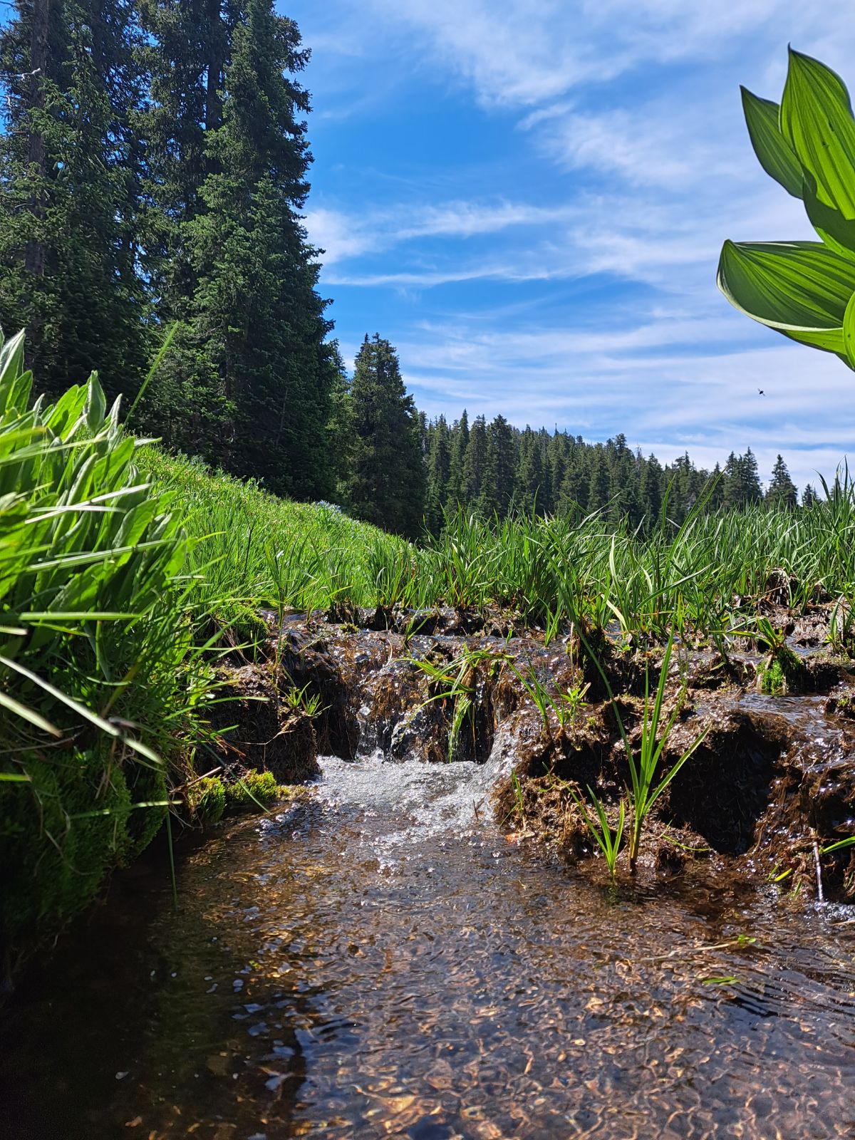
y becomes more and more dotted with pine trees. After 1 mile, you’ll encounter the Northgate Peaks Trail junction. Turn right onto the Northgate peaks junction and follow it for about 200 yards until you see a sign indicating the “Left fork of North Creek” and the “Subway”.

Shortly after this turnoff, the trail leads you to slickrock. Up to this point the trail is very well defined. Once on the slickrock, I expected to see cairns marking the route, but there was only 1 that I saw the whole first section. But we managed to spot the trail off in the distance though, as the slickrock gave way to a forested area again.

After about .5 of a mile, we left the trail off to the left to cross over Russell Gulch before it became more difficult. We actually crossed right before it became a canyon. After crossing we looked back and noticed a more defined trail that we had somehow missed. Once on the east side of Russell Gulch, begin climbing up the slickrock to the main ledge. Once on the ledge continue about another .5 miles. At this point, you can begin to see the canyon that makes up the Subway.

Once there is a substantial ridge to your right, descend toward the canyon and route find your way into Das Boot. There are very few entry points. The one we used was a small drainage which required a bit of down climbing to get into and then a little bit of down climbing to get from it to Das Boot.

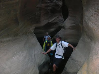
Shortly after our entry, the canyon walls narrowed as if to welcome us to our challenge. We started through the beautiful canyon along the dry river bed, coming to a few small obstacles every now and then. After a short time, we encountered our first technical section - a dry waterfall which had about a 12 foot drop. Apparently, a log used to make this obstacle a mere catwalk, but the log had been broken so the only way down was a drop. We got out the daisy chains and one by one lowered ourselves down – some more gracefully than others. Looking back on it, we could have all hung on the log and then dropped a short distance to the bottom, as Jason did, who unclipped the daisy chains and came down on his own. But we’ll chalk that up to it being the first obstacle of the day.

Shortly after our first technical section came the water. For the most part, we were only in up to our knees and occasionally our waist. Nick had mentioned that the water is normally much higher than it was. We did have one short swim of about 15 feet which kept me chilled for the next few hours.

The final obstacle we came to was about a 25 foot drop into a shallow pool (maybe 6 feet). After trying to figure out an easy way down, the group decided to get out the ropes and harnesses to repel down. I continued to look for a good down climb and found one off to the right. The dicey part was getting off of the main ledge to one about 5 feet below it which was only about 2 feet wide. I decided to go over the edge on my stomach which meant I couldn’t tell when/if my feet were about to hit the ledge – a scary feeling. Once onto the ledge it was a pretty easy down climb, albeit on very narrow ledges. The others in the group still elected to repel down after seeing that I had made it to the bottom.

This brought us to the entry point of the Subway. We arrived at about 11:15 and expected to see the other 3 members of our group waiting for us. But they weren’t there as we had expected and, after waiting for about 20 minutes, Nick decided to go up the trail a bit to look for them. He discovered that two of the others had turned back because of some steepness which was taking a toll on one of their knees.

We resumed our hike at about 12:00 and were now on our way to the subway. Not too long after we had started back up we came to another swimming hole. This swim was a little longer – maybe 25 feet. The water was much warmer in the standard subway route than it was in the Das Boot section, but still left me scurrying to find sunlight penetrating the canyon walls to warm my self up.

Just before entering the actual “subway” and about 1.5 miles from the Russell Gulch/North Fork Junction, we encountered Keyhole Falls. Many people down climbed this obstacle without much trouble. I was still shivering from my previous swims and down climbing would have meant that I would have to wade through chest deep water once again so I decided to repel (hand over hand) past the wading part and stay dry.

Once past Keyhole falls, the amazing beauty of the subway begins. Corridors are filled with pools of water of all kinds of interesting shapes – one even resembling a heart. Despite the many people that were there, I was still left feeling that I was discovering something incredible on my own.

Just out of the subway are the red ledges, a very beautiful series of small waterfalls over slickrock. Walking out of the subway and towards the red ledges gives the feeling of walking off the end of the earth, as the water flows over the edge, but what is over the edge can’t be seen.

We carefully made our way down the red ledges (very slippery) making sure to keep our weight slightly forward so as not to have the misfortune of ending up on our backsides.

About 1.5 miles out of the subway, there are some very distinct dinosaur tracks on large blocks of light grey mudstone located about 15 feet to the right of the river. They are hard to miss unless you are hiking with your head down trying to keep your footing in the water.

By this time the canyon walls have opened up. About 1 mile from the dinosaur tracks is the exit back to “Left Fork Trailhead” as marked on the signs. The ascent north is difficult, especially after the long hike negotiating obstacles and slickrock. Fortunately it is only about .1 of a mile and covers 400 vertical feet.

Once to the top, it is another .5 mile stroll to the parking lot. There are a few little trails that break off. For the most part, if you just stay on the main trail, which is to the left, you’ll make it back.

We made it back to the parking lot at 4:45 – an 8 hour 40 minute adventure. We hiked at a very slow pace, took tons of pictures and had many rest stops so the actual time for most people would probably be about 1 hour less than that.


Friday, September 4, 2009

Angels Landing, Zion National Park

I have hiked Angels Landing numerous times. Below are reports of a couple of the more memorable trips.

At Sunset 2009
I had originally planned to hike Angels Landing after work and be at the top at 8:00pm to view the sunset. I ended up getting a late start and was worried that I would quickly run out of day light – and miss the sunset. I entered the park at 7:00 and didn’t reach the Grotto area until 7:15. So, having not gone on a hike in . . . quite a while, anyway, I knew I was going to be hard pressed to make it not only by 8:00, but just before it got dark!

I started up the trail head at 7:16 taking in the beauty while walking at a considerable pace. I wondered what the few people who were on their way down were thinking about me as I passed them on the way up.
Anyway, I made it to scout lookout at about 7:45 – covering 2 miles of extreme up hill in 30 minutes.

The climbing section, covering the last .5 miles was a grueling experience. My legs were tired from the Walters Wiggles portion. But al last I made it to the top at 8:03 – 47 minutes to hike to the top of Angels Landing. But I was late, nonetheless, from my 8:00 time.

As I was on top, I took a picture of what was left of the sunset. There was also a lot of cloud cover, which lessened the effect. But the time on top was spent remembering previous hikes and feeling certain connections.

The climbing portion on the way down was difficult in the twilight. And once into refrigerator canyon, it became extremely hard to see any bumps in the concrete. Fortunately I brought my fanny pack which has a flashlight in it.

I made it back down to the tram stop at 8:49, just 1 hour and 33 minutes from when I started.

Angels Landing will forever hold a special place in my heart.


Valentines Day snow adventure 2013

Scout Lookout
For a day date, Liz and I decided to make the trek up Angels Landing. The shuttles only run from April through the end of October, at which time the road is closed to the non Zions Lodge staying public. It was nice to be able to drive our own car to the Grotto trail head, where the trek to Angels Landing starts.

We started on the trail at 11:28 in the morning on a brisk, clear morning. The temperature was supposed to get into the mid 50's so we knew it would be a nice day by the time we were finishing up.

We started getting a little worried as we started seeing more and more snow in shaded areas as we continued upward, having the trail pretty much to ourselves. The trail was clear of any snow and ice until we got to Walters Wiggles. Toward the upper switchbacks of Walters Wiggles the trail was completely covered with ice, which made one group infront of us decide to turn around. We decided to keep going and carefully made our way to Scout Lookout, where the West Rim Trail meets up with the Angels Landing Trail.

From here, we could see all the snow covered ascent that we would be about to conquer. I have become so accustomed to this hike that under normal conditions, I usually don't use the chains that are provided for safety. But today, the chains were a necessity. Snow and ice made the climb very slow, and many times we were required to pull our whole body weight up with just our arms because of the poor footing.

We finally made it to the top at 12:47 and talked a while with a group from Indiana, who had worn crampons to more easily deal with the icy conditions. We knew that descending a slippery trail would be even more dificult than acending it so we decided to get started back down after a brief rest to take in the views at the summit.

Although it was slow going, we made it back to our car at 2:28, exactly 3 hours from when we started.

Monday, August 3, 2009

Kanarra Creek (AKA Spring Creek Canyon)

Update 8/13/2019:

As of March 1, 2019, permits are now required for this hike for $12 per person and typically sell out about a week prior to the date they are desired. 150 permits per day are issued. Permits can be obtained at www.kanarrafalls.com

After trying to get a permit for the Subway in Zion National Park to no avail, some friends and I decided to try another slot canyon, just north of Kolob Canyons. Besides the Narrows, this would be my first attempt at canyoneering, albeit a tame one. Bruce Summerhayes, Nick McKinlay and I met at the gas station by exit 16 in Hurricane at 9:00. We quickly hopped in Nick’s truck and were on our way. We took exit 41 and headed north toward Kanarraville for a couple of miles. One in the small town we found 100 North, took a right, and followed the road for a short distance until in turned to dirt. We saw a gate with a sign indicating that parking for the hike was back in town. There was an obvious parking area just off to the left before reaching the gate so we pulled in there and were on our way at about 10:00.

The trail starts by passing through the gate and hiking towards the water tanks. Once past the tanks the trail descends into Kanarra Creek Canyon. Soon the creek is visible to the right and the trail enters the creek after about .5 of a mile.

For most of the hike, there are short trails to avert the water if you so desire. Because the water was usually only a few inches deep, it wasn’t too much harder to just stay in the creek. Soon after we entered the creek and the cliffs started closing in, my GPS unit lost reception.

The water was cold and my feet soon began to ache and became numb shortly thereafter. As we entered the “narrows” the high water marks were visible in places and it was a reminder to us that this was not the place to be in a flood. We also noticed one of the old ladders (used for assistance in climbing the two waterfalls) that had apparently been washed down stream during a flood.

We came to the first of two obstacles – about a 10 foot waterfall. At the time we hiked it, there was a makeshift ladder with wooden rungs nailed into it with a short section of metal also for two footholds. There was also a rope hanging off to the right for balance, I guess. All in all, a pretty easy obstacle to get up, assuming that you are placing your feet in the center of the wooden rungs and not on the edges where they would twist a little.

Once up, the canyon walls are still just feet apart. About half way in between the first and second waterfalls, there is a little pool with a natural water slide going down into it. Bruce decided he would slide down on our way back.

We continued on and came to the second waterfall. This one was a little more challenging to get up. The water from the waterfall was poring down on the ladder portion, which was only about 4 feet high. The pool of water by the bottom of the ladder was also one of the deeper pools we encountered. The ropes attached to the right side of the wall came in handy here. Once to the top of the ladder, I grabbed the rope and hand over hand climbed as I carefully placed my feet on wet rock where the water from the water fall was coming down. It was a short hand over hand but with the slippery rock, made it a bit more challenging.

After the second waterfall, there is a short section of narrows and then the canyon starts to open up a bit with much more vegetation than had been present earlier. We hiked for about another 1-2 miles up stream and finally decided to stop, eat our snacks, and turn around and head back.

Retracing our steps was easy and quick. Our feet had also warmed up by this point. But the exciting part on the way back was watching Bruce go down the “water slide.” The pool at the bottom was only about 5 feet deep, and Bruce swears he saw icebergs floating in it. At least I was cold watching him!

We made it back to the truck about 1:00 after hiking for about 3 hours. I would guess that we hiked about 5 miles round trip, though my GPS unit showed about 2.8. It was out of reception range for a majority of the hike. Kanarra Creek was a very beautiful hike, similar to the Narrows in Zion National Park, but with much tighter sections of narrows and with a couple of waterfalls that needed negotiating making it a little more interesting.

Monday, July 6, 2009

Signal Peak, Elev 10365

*Updated July 2023 at the end

The first real hike of the year! Since we’ve moved to Southern Utah, I have only been on a handful of hikes – a day hike in the Grand Canyon and Angels Landing at the end of last year, and Mollies Nipple 3 times this year (a short hike with only about 1200 feet elevation gain). So needless to say, I was in poor hiking shape, but overly anxious to get out there.

I tried to find my topo software to download to my GPS but it has been misplaced in the 2 moves we’ve had in the last year. So I was going blind into a mountain range I had never set foot it – a great situation for someone who gets lost in a bathroom. . . I did have a hard copy of a map of the Pine Mountain Wilderness, so I did have something to refer to.

I got on the road at about 8:00 and took I15 north to exit 22 in Leeds. Then head west on Silver Reef Road for about 8.6 miles until you reach the Oak Grove Camp Ground. While on the unpaved Silver Reef Road, you’ll encounter a fork in the road after about 3 miles. The left fork heads to St. George so stay right! Once to the camp ground there is a small parking area off to the right side of the road after passing a couple of camp grounds.

The Trail Head is well marked and is even visible from the road. I parked, used the rest room and headed up the trail at about 8:55. The sign indicates that it is 3 miles to the summit trail.

After ½ a mile, a sign marks the Pine Valley Wilderness. The first 3 miles to the summit trail are at a fairly steep grade and I was a little concerned when I started feeling it in my legs much sooner than normal. At about 9800 feet I reached the top of the ridge I had been looking at in agony for the past couple of miles, only to see the trail descend the other side – a frustrating thing for me, to lose elevation I had just gained.

I should mention that the trail for the first 3 miles was well defined and easy to follow, but after dropping over the ridge at 9800 feet, it became a little harder to follow. There were a few sporadic cairns to help but I did have to use some route finding to get back to the trail.

At about 9600 feet I saw a sign that was facing the other way. As I walked around to see what was on it, it pointed to Further Water off to my left and Whipple Camp Ground, I think, to the right. I knew I needed to go to Further Water, so I made a left.

I soon made my way to Deer Flat, 2 pretty meadows surrounded by pines in all directions. Once out of the meadow, the trail began climbing again at a gentle pace. After about another mile I came to Further Water. I had to cross a small stream, running from the spring at Further Water. This was an even bigger meadow that Deer Flat and very pretty too with a small stream running down the left side of the trail for a while.

Once through Further Water, the trail climbs rather steeply for a little bit. After a few hundred yards, a series of cairns are staggered along the fairly well defined trail. Near the cairns, there is a small wash. This is a good spot to leave the trail at about 9950 feet and begin bushwhacking to the summit.

Unfortunately, I didn’t realize this at the time and hiked for about another mile to the base of Burger Peak. I knew I was in the wrong place because there was a cliff band off to my left which I could easily find on the map. So I turned around and went back to the base of Signal Peak and started the bushwhack.

It was a fairly tame bushwhack with not many obstacles in the way other than the occasional fallen tree or patch of vegetation. I reached the summit at about 1:00. I first came to a large cairn which I assumed was the summit, but after exploring a little, I found a slightly higher location and two registers contained in glass jars covered with tin cans.

I signed the register, took some pictures and headed back down. I had already eaten my snack on the way up (further indicating to me how out of shape I was since normally I eat on the summit if at all). The summit was slightly disappointing because all the pine trees obscured the views.

On the way down, I startled a deer who, in return, did the same to me. The final 3 miles were brutal and I thought they would never end! Ascending them was much easier for me then descending them. I reached my Pathfinder at about 2:50, out of water and ready to soak in a warm bath!

The total hike took me about 6hrs and 4mins, was 10.7 miles and had an elevation gain of 4718 feet. The mileage and time are a little skewed because of my little excursion out of the way.


*UPDATE*

My 16 year old son and I hiked Signal Peak again on July 17, 2023. The road to get to the Oak Grove Camp Ground is a dirt road for about 8 miles and was pretty rough in places. (My passenger car is currently in the shop fixing a rattle that started because of the washboard from the road). The hiking trail was much more overgrown in places and would benefit from trail maintenance. Also, once we crossed to the back side of the ridge, the trail pretty much is non-existent other than some intermittent cairns. It was a hot hike, registering 106 degrees in Leeds when we got back to the car. Here are some pictures from 2023:  

This sign is found at the start of the trail near the Oak Grove Camp Ground.

When the trail first starts, it is well defined through tall grass.

This sing marks a trail junction not long after the start of the hike. (The Oak Grove Trail is the one you want to take to reach the summit of Signal Peak).

Here the trail is quite overgrown.

In some spots on the front of the mountain, the trail is faint but still discernable. 

Here's a another look at the trail as it winds its way toward the ridge top.


The best view of the Hurricane/St George Valley comes at the ridge top, not the Signal Peak Summit (which is obscured by trees).


Once over the ridge, the trail loses about 200 feet of elevation as it descends to the Summit Trail. Once to the bottom of the drainage, there is a sign facing the opposite direction for some reason. 

To reach Signal Peak, head towards Further Water, which is off to the left (opposite of what is seen here since the sign is facing the opposite direction from the trail you just came down).

Soon the trail brings you to a really cool meadow. The meadow is very long, and split in two by a couple of pine trees. The trail is pretty well worn through the meadow.

The trail leaves the meadow by heading through some pine trees that are over growing the trail.

After the meadow, the trail becomes non-existent as it heads back into the forest. Fortunately, every now and then, a cairn can be spotted to help you know you are heading in the right direction.  

The next big meadow is further water which can be identified by a spring which provides a small stream through the meadow.

We stopped for some pictures.


Unfortunately I didn't get any pictures of where we started the ascent of the Signal Peak summit. There is no trail to the top. We went up a rocky "wash" which made for pretty easy hiking, although at a pretty steep grade. Here is a look at Trey descending down the same rocky area to get back to the Summit Trail.

It was a hot day with no cloud cover (despite what my phone said). But we each had a camel back and carried a total of 7 additional water bottles. That was just enough for us as we made it back to the car with 1 bottle left.