Thursday, August 12, 2010

Humphrey's Peak elev 12,633' High point in Arizona


Time to hike another state high point! I only live about 270 miles from Flagstaff, which is where Humphrey's peak is located, and it has been calling my name for sometime now! As I looked to see what the most direct route to get there was, I noticed there were 2 ways - either through Zion National Park and on through Kanab and Page, or the southern route through Colorado City, Fredonia, and Jacob's Lake. Although there is a little winding through the Jacob's Lake area where the speed limit is 40 miles per hour for a total of about 15 miles, it still seemed like it would be about as fast and much shorter than the northern more route.

I had 2 days off in a row and so I originally planned to go on Wednesday, my first day off in case I decided that I wanted to stay overnight because of weather or fatigue. But the weather looked bad for Wednesday and on Tuesday nights I play volleyball till midnight, so I wouldn't be able to get an early start on Wednesday which meant more possibility of running into a thunderstorm in the afternoon.

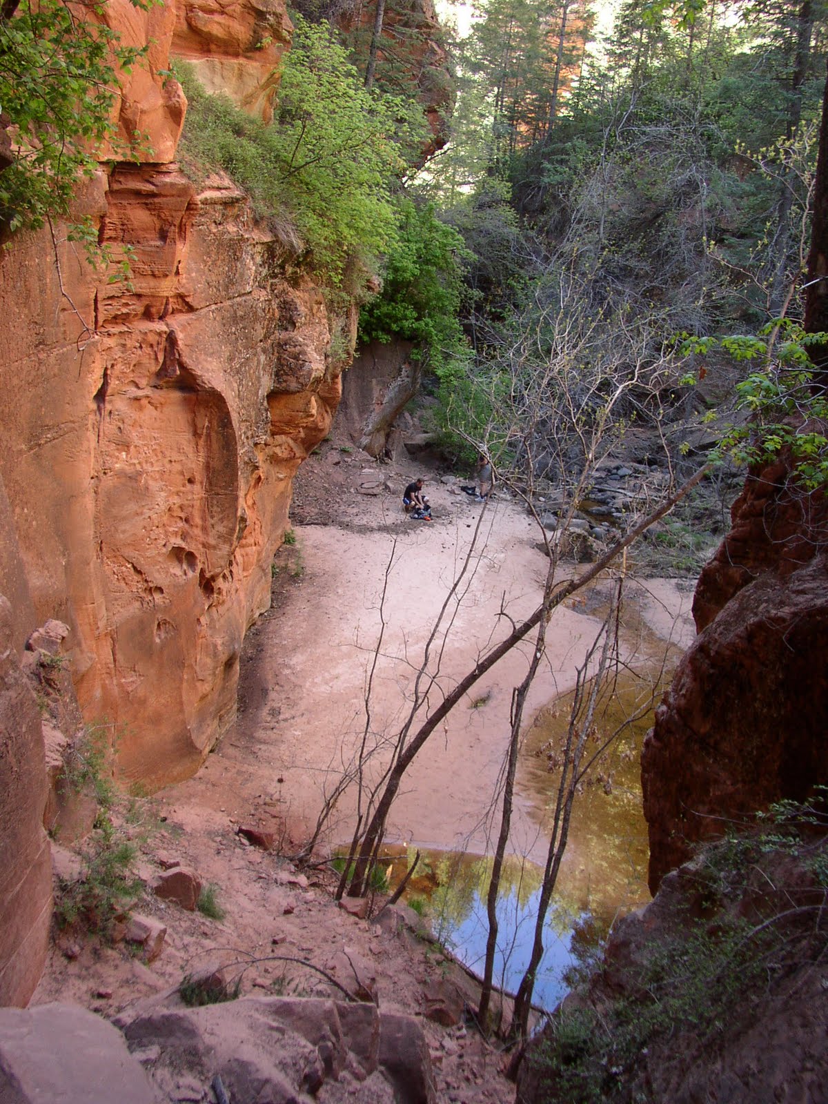
So Thursday it was! I woke up just before 5:00, ate breakfast, gathered my gear and was off at 5:30. I was familiar with the route to Jacob's Lake as I had been there a couple years ago when I visited the north rim of The Grand Canyon. I had no idea how beautiful the scenery would be past that though! What I saw caught me completely off guard and I stopped at one point at a look out to take a picture of the amazing contrast between the green valley floor and the red rock walls that jutted straight up hundreds of feet.

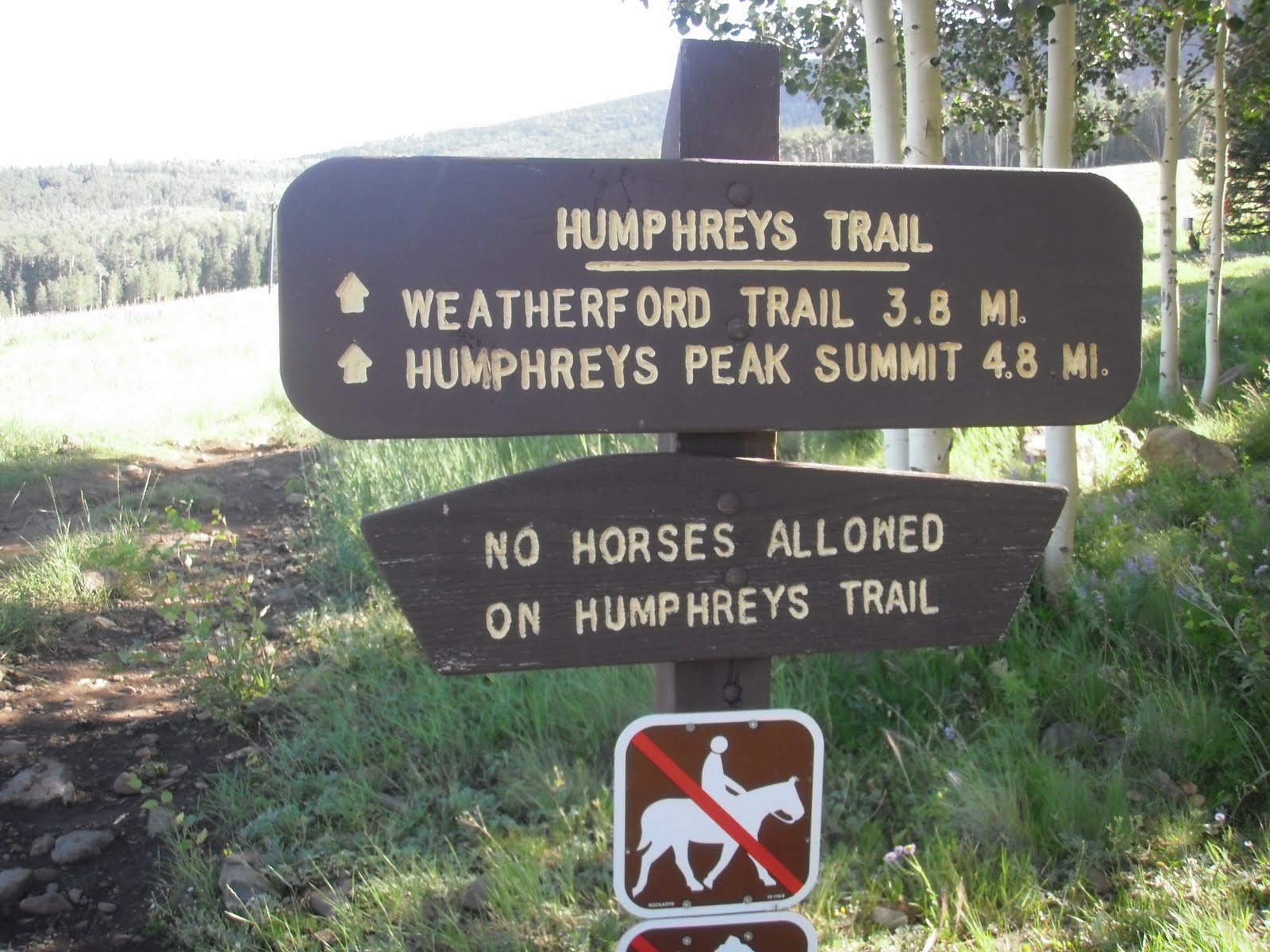
I got to Flagstaff with no problem, drove through the town a ways, even touring "old town." At Humphrey's road, I took a right which lead me to hwy 180 north. I followed 180 for 7 miles to a sign on the right hand side of the street which indicated that the Snowbowl ski area was at the next right. I took a right immediately after the sign and followed that road another 7 miles to the Lower Snowbowl parking lot (elevation 9320) and easily found the trail head at the north end of the parking lot.

I arrived at the parking lot at 9:45 and started up the trail at 9:47. The well marked trail starts through a colorful high mountain meadow, under a ski lift as it heads to a forest made up of tall pine trees mixes with aspens.

The scenery soon changed from the openness of the meadow to the dark, shaded forest. Nothing fills up your senses more than a hike in the forest, especially after doing mostly canyon and desert hiking for the past couple of years. Every sound from the wind rustling through the tops of the trees 50 feet in the air, to the faint bird chirps, to the creaking of the trees about to fall, gets and holds your attention.

Through the forest, the trail was very unstable, walking over many roots and rocks. Not long after entering the forest was a trail register, which I signed. At about 10,100 feet, the trail makes a sharp switchback to the right. This was the only spot I lost the trail. The spot is marked with a cairn, so when I couldn't locate the trail a few yards up, I retreated to the cairn and found where I had made my error.

As I reached the 11,000' elevation mark, the trees became more sparse and the surrounding area started opening up. I could see the top of a ski lift on the mountain opposite where I was across the canyon. There were also a couple of rock slides around the 11,400' elevation point which offered a new terrain to cross. Out of the forest, the wind became much stronger and I was forced to tie my hat to my backpack at about 11,600'.

I encountered a sign at about 12,100' informing hikers that there is no camping above the tree line. Soon after, I came to the Weatherford saddle between Agassiz and Humphrey's peaks. From here, the trail is a little less defined but there are posts that help mark the way, if needed. For the most part, the trail stays just below the ridge line most of the way up.

After passing a couple of false summits, I made it to the summit at 12:10. The summit was incredibly windy! In fact, a got blown around a bit on the final ascent to the top. There are 3 rock "forts" at the top to help shield the wind. They helped, but I still put on my thermal sleeves, snacked, took pictures, and talked with other hikers at the summit for about 50 minutes before heading down.

I could faintly see the north rim of the Grand Canyon. More distinct were the beautiful Vermillion Cliffs that I had passed on the way. I was very happy that the cloud cover had left the mountain top - driving in, there was a blanket of clouds over the summit and in talking to a hiker on the way up, he said that the clouds had been there for the past few days. The views were amazing, eventhough standing up for long periods of time was exhausting and cold, constantly battling the gusting wind.

I started down at 1:00, once again getting blown around by the wind. As I headed down, I was able to take in the views I missed as I was headed up the mountain. I made quick time, even jogging part of the way, and was back to the trail head at 2:37.

In total, the hike took 4 hours and 50 minutes, with 50 minutes of that resting on the summit. One more high point down!
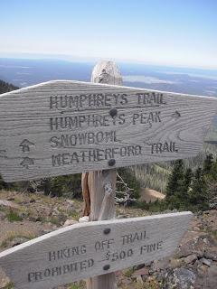
Thursday, July 22, 2010

Fairyland and Navajo Loops Bryce National Park

I had only been to Bryce National Park once before and never had done any hiking, so I thought I'd take a short excursion to the Park and do a little exploring. I decided in the morning I wanted to do a "strenuous" hike, and in the afternoon I'd do something a little more Moderate/Easy.
When I looked on line for some interesting hikes to do, Fairyland Loop Trail looked like a good one to try out in the morning. It starts out at Fairyland Point which is located before actually reaching the entrance station on a road that comes in from the left.

I arrived at the trail head at 7:12am and started on my way. One thing that is very visually appealing about hiking in Bryce is that the trails are so easily defined and can be easily spotted from a ways away.

I rapidly began losing elevation as I dropped from the rim into the canyon amongst the hoodoos. On my way down, I spotted a doe and her fawn just up the trail a few yards. As they saw me coming they left in a hurry down the trail.


The sun still hadn't risen above the canyon walls but the hoodoos seemed to glow despite being in the shadows. I crossed several dry river beds which were probably very active rivers in flash flood situations. I also crossed one section of the trail that had been moved and reblazed just over to the side due to a massive rock fall.

I made a short excursion of about 200 yards to see the Tower Bridge - a natural bridge with a tower like rock jutting out behind it. Soon after, the trail took me into what is known as the "Bryce Amphitheater." Beautiful views of amazing rock formations were visible all around me!

Shortly after Tower Bridge and entering the Amphitheater, I started gaining back all of that elevation I lost on my way into the canyon. I knew I would eventually have to start climbing to meet up with the Rim Trail, which is what I took to get back to the trail head.

I reached the Rim Trail and took it back to Fairyland Point, noticing the Bryce Lodge and a few other buildings along the way. A sign indicated that I would be on the Rim Trail for 2.5 miles. It was a relatively flat 2.5 miles with views of the trail I had just been on across the canyon.

I made it back to the trail head at 9:44 after 8 miles of hiking. It was a very picturesque hike that I hope to do again!
In the afternoon, I did the Navajo Loop which was absolutely amazing! From what I've read, it is the most popular hike in the park, and for good reason. The beginning of the trail takes you 550 feet down steep switchbacks through "Wall Street." From the Canyon Rim looking down, Wall Street looks like a dark abyss which actually seems inviting when standing in the hot sun! This portion is definitely the highlight of the hike.


Soon after leaving Wall Street, there is an option for a short excursion to 2 bridges, a cool formation just up a small side canyon. I got a picture there and then headed up the trail to the rim again, a 550 vertical foot hike.


After 1.3 miles, I made it back to the top. This was a REALLY pretty hike!

Saturday, July 17, 2010

The Narrows, Zion NP


I had been through the narrows twice before, but the last time had been about 5 years earlier...so it was time to go again!

I got to the Chamberlain's Ranch trail head at 9:55 and started on my way. I remembered in the past trip with my brother-in-law Jeff, we spent about 15 minutes at the beginning trying to figure out how to get across the river without getting our feet wet, as the first couple of miles of the hike is along the river bank and not in it...Anyway, after all that time trying to figure out how to keep our feet dry, I still managed to make an ill-advised jump and got a foot wet anyway. Needless to say, this time I just went right in and forded the stream.

I came to the cabin at 10:46 after about 3 miles. Soon after this, the trail entered the river and I was on my way. For the next few miles, the canyon walls continued to creep in closer and closer all the while getting higher and higher. At 12:31 I encountered the first stretch of narrows. I also noticed that many new obstacles and mini waterfalls had formed since the last time I went on the hike.

At 1:45 and after about 8 miles I encountered the waterfall, North Fork Falls. This is easily bypassed by a notch on the left side of the trail, which, if you didn't know it was there, would be easy to miss. The falls are about 20 feet high and the force of the water coming down is enough to make it nearly impossible to hike back to the base of the waterfall once down.

I encountered the confluence with Deep Creek at 2:57 after about another mile of hiking. Deep Creek has about as much water flow as North Fork so from this point on, I would be hiking in twice the volume of water, with the canyon walls much more narrow than they had been before - meaning the current would be stronger and the depth of the river, deeper.
Over the next 3 miles, many campsites are found, each numbered from 1 to 12. Also, a smaller stream, Kolob Creek, adds a little more water flow to the river. It was here I camped on my overnight trip with Jeff. It's a perfect place to filter some water!

From here, the hike becomes more difficult. The rocks are more slippery, the water deeper, swimming becomes the only way to make it through certain points (depending on the water level that year) and you're just plain more tired...
I came to the Grotto, a cave like structure carved out over the years by water flow through the canyon, at 4:01, and to Big Springs about an hour later at 5:05. Big Springs marks the 11.5 mile mark and is a pretty place for some pictures. It was here that I first encountered the day hikers coming up from the bottom (Temple of Sinawava). Also, after Big Springs was the only swimming spot I found.

After 2 more miles filled with deep water and slippery rocks, I encountered Orderville Canyon coming in from the east (left). I should say here that I was happy to have brought my hiking pole to use as a depth check for the river. Although it was actually clear this hike and I could see the bottom for much of the hike (the previous 2 hikes it was a muddy brown color with no visibility), there were portions where the water was too deep to see the bottom. So I poked and prodded along with my hiking pole to determine if I'd be swimming.


Not long after, I made it back to Riverside walk and the shuttle stop for the Temple of Sinawava at 8:25 and after 16 miles of hiking!

Saturday, July 3, 2010

Pine Valley Mountains

I got invited to do a little hiking this morning! The plan was for a couple people to drive up to the Oak Grove campground and begin their hike there, and the rest of us to travel to Pine Valley and park our car there. Then we would meet in the middle, exchange car keys, and continue on.

It was a perfect Saturday morning - a rare Saturday off for me from work! I was picked up at 4:45am at my house and we picked up a couple of other people and continued on to the town of pine valley. Once in Pine Valley we got to main street, took a left and followed main street until we came to a thin brown sign off to the right side of the road that indicated that we needed to turn right onto a dirt road to find the Forsythe Canyon Trail head.

We had planned to take the Forsythe Canyon trail (#3021 on maps) because it offers better views into St. George. From there we skirted around Burger and Signal Peaks, through Further Water, and ended up taking the Oak Grove Trail (# 3030 on maps) back to the Oak Grove Campground.

There was a crisp, cool feel in the air when we arrived at the trail head at 6:02. We got all our gear together and got on our way at 6:06. The trail head is marked by a big sign and the Forsythe Canyon trail is well maintained and easy to follow. As we started out, I took out my camera to take a picture of the trail head and realized that my batteries were just about dead. The two pictures I was able to take both came out blurry.

The first 2 miles of the trail is very pretty with about a half dozen river crossings - most just rock hopping, but there was an occasional makeshift log bridge. The rivers were beautiful as was the greenery surrounding them.

After 2 miles, we started gaining elevation at a steady pace. It was here that my GPS let me know that it was running out of batteries, and with my spare batteries in a different pack, I knew this would be a technically deficient hike...

We continued the gradual incline over the next 3 miles until we came to a sign indicating that the Blake-Gubler trail veered off to the right of the main trail. We continued on the main trail, passing Burger peak and coming to a cliff band that offered some great views of St. George. It was here that John and I (who had broken off from the main group) encountered Jeff and Kevin who had started from Oak Grove.

We chatted for a couple of minutes and then went on our way, exchanging keys to our cars. As we neared Signal Peak, I could feel it calling my name, begging me to hike it...So I asked John if he minded if I ran up to the summit or if he wanted to come along. (we hadn't originally planned to summit signal peak) He was a little hesitant due to the major uphill portion of the hike that we had just finished, but decided to come along.

My main concern was that I knew we had to be fast so our party that was behind us didn't pass us and not realize we were behind them. Although some of them were experienced hikers, the trail in this area is very hard to find in places and I knew I should be with them to help them. So we rushed up to the summit, signed the summit register which is found in a red can on the far west side of the summit, and headed back down.

On the way down from the summit, I was actually a little nervous as well, that we wouldn't be able to find the main trail because it was so faint. We ended up timing it perfectly as we saw the rest of our group hiking along the main trail below us as we descended. We joined up with them and continued toward the beautiful meadow at Further Water.

Further Water is a large, breathtaking meadow nestled between pine forests on both sides. Both times I've been there, I can't help but wonder if a bear is watching us from the safe cover of the pines. The meadow has a creek running through it and is dotted with green, bulb-shaped plants that grow in clusters and offer a beautiful contrast to the light yellow-green grassy meadow.

At the end of the meadow, the trail crosses the stream on the right side and continues up the hill. We continued on for another mile until we came to a second, smaller meadow. Not far past the second meadow, we came to a sign indicating Brown's Point trail to the left. What was not mentioned, save for someone writing it on the sign in pen, was that the trail to the Oak Grove campground was off to the right up the drainage.

We started up the drainage and encountered large snow banks. Jeff had shown us a cut on his hand earlier where he had fallen on one of these snow banks so we knew we needed to be careful. Not too long after starting up the main drainage, a second drainage comes in from the left, and we took it to get to the saddle. The last few hundred feet were severely up hill and took their toll on several in our group, but once to the saddle, we were rewarded with amazing views into Hurricane and Zion National Park.

From here, it was literally all down hill. 3 miles of knee crushing, steep down hill. I took it slower down the trail, trying to take it as easy as I could on my knees, which always seem to suffer the most on hikes.

We made it back to the car at 12:14 and waited about 55 minutes for the rest of our group to make it down. Overall it took 6 hours and 8 minutes and was about 12 miles long, including our excursion up to Signal Peak summit.

Wednesday, June 23, 2010

The Virgin River

Ever since hiking the Narrows, whenever I see the Virgin River I want to hike it! I mapped out a shorter course that would be a pretty easy hike and decided to make the attempt. I had mentioned to Dan Lackey that I was going to do a little exploring in the river and he asked if he could come along.

I had planned on starting right at the Sky Mountain Golf Course. From what I’m told, there is a trail down to the river from near the clubhouse. But Dan mentioned that there was another way that started near his house.

So I dropped my car off at the end of 200 West in Hurricane and had a friend drop me off at Dan’s house where we started the hike about 11:50. We crossed hole number 17 at Sky Mountain and dropped down into a side canyon that connects with the Virgin River canyon after about a quarter mile.

The trail down was steep and there was actually a makeshift ladder (although not too sturdy, but sturdy enough) that we used to climb down a 10 foot section. Once to the bottom of the canyon, we bushwhacked our way through some overgrown vegetation and made it to the Virgin River.

Once to the Virgin river we turned right (north-east) and started up stream. The water felt warm and refreshing - especially when compared to the frigid water I had encountered a month earlier in the Subway. With the temperature reaching 100 degrees, it was nice to get in the water. I have to admit, the first time we had to ford the river, I was surprised by how deep it was.

I soon realized that this wasn’t just a fluke section of the river that was deep, but the whole river was deep and flowing fast! This made hiking straight up stream rather difficult for extended periods of time. But when we got out of the river and hiked along it’s banks, we soon found the biggest hindrance of the hike - biting flies!

Fortunately for me, I decided to wear long pants because I was unsure of what type of vegetation we would be forced to hike through. But Dan wasn’t as fortunate in his shorts. The flies were eating him alive, and without any bug spray, we were forced to hike up the river where the water kept his legs covered. It also tired our legs out!

After about 2.75 miles, we came to a small bend in the river with a sheer volcanic face wall. The bend in the river was caused by a huge volcanic bolder that seemingly fell from somewhere high above. The whole scene was amazing and as I noticed the hills that once were very active volcanoes, I found my self thinking about how amazing it would have been to see this area being formed.

It was here also, that we noticed a father and son floating down the river on inner tubes. Although this would seem like a fun idea, even with the river being as deep as it was, there were many spots filled with obstacles that would, I would think, require walking the inner tubes around all too often to be worth it.

About a mile and a half past the bend we came to "Rabbit Ears" a volcanic rock formation on the right hand side of the canyon aptly named for what it looks like. Not long after passing rabbit ears, we caught our first look of civilization - some houses off in the distance overlooking the river. I recognized these houses from when I used to take my kids on the hike down to the river, so I knew we were close.

Soon I saw the top of a chain linked fence off to the right hand side which I knew was the top of the desert tortoise habitat and also recognized the sandbar that my kids and I played on. So we exited the river and started on the trail past the tortoise habitat that ascended out of the canyon and up to 200 East where my car was parked.

We made it back to the car at about 2:25 after 4.68 miles and about 1000 fly bites! I would definitely do this hike again, but bug spray is a MUST!


Tuesday, June 8, 2010

Observation Point, Zion NP


I have wanted to climb Observation Point for quite some time. I had been on part of the trail before a couple of times; once on the way down from the east rim, and twice when I hiked hidden canyon.

With a day off from work and a beautiful day to enjoy it, a hike was the perfect solution! It was 105 degrees in St George, so I knew it was going to be a little warm. I drove to the Zion National Park Museum and parked, and took the shuttle to the Weeping Rock stop - the second to the last stop.

I started my hike at 10:46, with the sun quickly rising above the canyon walls. The first portion of the trail is paved, taking you past the turnoff for Weeping Rock to the left. It then quickly starts climbing on long switchbacks and the paved trail becomes a bit bumpy.


After about 1.5 miles, the hidden canyon trail intersects the observation point trail. Stay left to continue to observation point. Several more switchbacks continue upward until you are brought to one of the most scenic and beautiful sections of the hike, Echo Canyon.

Echo Canyon is made up of narrow walls which completely block out the sun for the most part from the ground. During the late summer, there is very little water in the canyon, which would make conditions for exploring it, ideal. This time, though, Echo Canyon was filled with frigid water which would have made for a chilling experience! I decided to continue on the trail, determined to come back to explore this amazing canyon at a later date.

After leaving Echo Canyon, the trail begins ascending again, and soon the East Rim trail comes in from the right. This was as far as I had been on the trail before. From here, the tail ascends slightly, but at a much lighter grade than before. Another break-off trail, indicating 2.5 miles to the park boundary also comes in from the right.

Past this sign, the trail turns into a mixture of sand and rock for the remaining .75 miles to the final destination. I made it to the top at 12:10 and took in the amazing views down canyon. The most notable landmark, being that of Angels Landing, which looked so small from Observation Point. I also noticed the small slot into Hidden Canyon, where I had been just a few days before. After eating lunch, taking pictures, and just taking in the beauty of the surrounding area, I started heading down at 12:45.

The descent was hard on my knees but took no time at all. I was back to the shuttle stop at 1:52, after 3 hours and 6 minutes, 35 minutes of which was resting on the top. It felt good to sit on the shuttle and enjoy the ride down letting my knees have some much needed rest.

Tuesday, May 25, 2010

The Subway, Zion National Park

I was informed by Nick McKinlay that he had an extra spot for me in his hike through the subway so I couldn't pass up another opportunity to take part in the great adventure. The original plan was to once again do the "Das Boot" route, as we had done the previous September. But in talking to one of the rangers, Nick was informed that to do the "Das Boot" section this early in the year would be dangerously cold, even with wet suites. So we decided on the normal Subway route which I was excited about since I had never done it before.

We met at the Lins parking lot in Hurricane at 7:15 and drove to the town of Virgin where we took a left on the Kolob Reservoir road. From there it's about a 8 mile drive to the Left Fork trail head, where we left one car and all piled into the other for the final 7 mile drive to the Wildcat Canyon Trail head, arriving at about 8:05.

We got our gear together, took some pictures, left the keys to our shuttle vehicle that was parked at the Left Fork Trail head in the car...ooops...and got on our way at 8:18. There were 6 of us in the group - Nick, his mom and step-dad, mom's friend, myself, and one of Nick's friends.

The hike starts through the open meadows of the Kolob Terrace, which are dotted with Ponderosa Pine trees. Soon, the trail goes through a forested area. After about 30 minutes, we came to the Northgate Peaks trail, which comes in from the right. This is the trail you want to take for a short while, until a clearly marked sign marks the subway route which breaks off to the left. From here, the trail leaves the shade of the trees to open slabs of rock. The trail is marked by cairns for the most part, but if you just continue down to the gully below, it is pretty easy to pick up the trail again as you enter another forested area.

We new there would be a lot more water than our trip last year because of all the rain we had received this spring. As we continued hiking and encountered numerous flows of water down the slickrock, we knew our hunch was beginning to be proved correct.

The trail continues to the left of a noticeable huge gouge at seemingly the end of the canyon with many trees growing out of it. Once up and over the saddle another steep decent of slick rock is encountered. I snuck an occasional peak over to the shelf to the left, to recall the Das Boot route we had taken before.

After a short hike through some scrub oak, we finally came to the steep decent into the canyon. It was actually quite a bit steeper of a decent than I was expecting and if memory serves me correctly, much steeper than the Das Boot route.

Those who had wet suites changed into them. I put on my neoprene socks and made sure all of my gear was stored water tight in my pack.

We started down the canyon and after about 10 minutes, encountered the first obstacle - a jumble of giant boulders. Last time, we chimneyed down the rocks to the far right (about 15 feet up). We went over that way first, but because of the water in front of the giant boulder, we decided to try to down climb the front of the boulder as far as we could and then slide down the remaining 10 feet or so into about 2 feet of water. We all did it this way except for Nick's mom, who slid down the waterfall to the left side of the boulder into a pool, maybe about 4 feet deep. As there are rocks under the water there, I don't recommend doing that. When it was my turn to go, I down climbed the front using the small hand and foot holds and the slope of the rock to keep me on it. As I got lower to the water, the holds began running out and the slope was about 90 degrees. Under normal conditions, I probably could have down climbed to a gentle 5 foot drop into the water, but because my hands were about numb and my forearm muscles tight, I lost my grip about 8 feet up and slid down the boulder into the water. No harm done...

About 15 minutes below the first obstacle is the triple pool which presented us with our first required swim. I wasn't looking forward to this, remembering how cold I was last time, after I got wet...but this time, even though the water would be a few degrees older due to the time of year, I decided not to wear a cotton shirt, opting instead for my nike thermal top, which would dry out much faster. I jumped in and started the swim. I could feel my muscles tightening as I entered the frigid water, but after a few doggie paddles with hat in hand (it was knocked off when I jumped in), I was to the other side.

As we continued on, we noticed several small springs that added water to the canyon. Another 15 minutes or so later, we encountered the next swim where the canyon formed a slot filled with water. This is where we had our first scare. To get to the swim, you have to down climb about 10 feet while water is pouring down on you. This was made more difficult than normal because of the higher water levels and stronger flow. I was the first to make the attempt. As I sat on the top of the rock with water rushing past all around me, somewhat pushing me forward, I tried to put my foot down into the middle of a small pool of water below. But when I couldn't feel the bottom, I quickly lifted it out as my momentum was pushing me forward and placed it on what looked like a small arch on the far side of the little pool. It held and I steped over onto it, staring at a small, pool of water that I was sure to have to swim through. I jumped in and swam through the long dark corridor to the large open area at the end. I quickly made my way to the sunlight to try to warm up.

This is when I heard some commotion back in the slot I had just come out of. Nick went in after me and jumped into the middle of the first small pool that I couldn't feel the bottom of. I didn't want to go in the small pool when I went because of the incredible force of the water fall that would be coming down on my head and back. His foot got stuck momentarily between some rocks but he was able to get in loose quickly and start the swim. His mom was next and she ended up getting stuck in that small pool as well. It took her a little longer to get out, which is what was causing the commotion.

We pressed on and after about another 10 minutes came to Keyhole Falls. I walked down what seemed to be a very strategically placed log that was slippery, but with care, manageable. This led to a little more swimming and a beautiful corridor. At the end of the corridor, the canyon abruptly turns right, where many small pools are encountered, one resembling a heart!

We then crossed over to the left side of the water flow at the top of the waterfall. With no rope, the easiest and safest way is to down climb near the bottom of the waterfall, which means one more swim through a small pool. If you have rope, you can bypass the little swim by continuing a long the ledge about 50 feet where there is a bolt attached to the rock. This allows for about a 30 foot rappel, which we did last time.

Once past this final obstacle, I took in as much of the beauty as I could while shivering and then headed for the sunlight where we took a break and stopped to eat. I also had brought a change of dry clothes, which I changed into. Finally starting to get warm, I was able to look back up canyon and really appreciate the beauty of the Subway!

While we stopped, we talked with a couple of hikers who had passed us on their way. They agreed to take Nick back up to his car since because we had left the shuttle keys in it, it was either find a ride up or hike 7 more miles.

As we got started, we determined that we would all start off together but that to keep up with the hikers who would be giving us the ride up to our car, we would split after a while and let us each hike at our own pace. The first part out descends some beautiful small waterfalls over slickrock red ledges. This is where I had my little spill and we had our first fatality on the hike - my camera! There was talk of retirement for the camera long before this hike, though...

Once past the slick rock waterfalls, the canyon walls open up and the trail crosses the river a few times but for the most part stays above it. On one of the crossings, as my feet felt the chill of the water, I was reminded of just how cold I was a short time before!

We made it to the dinosaur tracks at 2:12 and then back to our car about 3:35. The trail that takes you out of the canyon is marked by a small sign with a boot print on it by a trail that cuts up to the right of the river. The hike up is notorious for being difficult - about 400 feet in about a mile. I found it to be a nice way to warm up my muscles that had been frozen for so long.

The hike is about 8.6 miles and took us about 7 hours at a very leisurely pace.