Jan 17, 2013
The weather was just turning warm enough for a hike, and with the destination being in the Mesquite, Nevada area where the temperature is a couple of degrees warmer than where we live, it was time to check out some petroglyphs. I had read a newspaper article about the Falling Man site, as the Whitney-Hartman site is commonly referred to, a week or so before the hike and used the directions in it to find my way.
We took I-15 south out of St George, Utah and followed it 5 miles past Mesquite to exit 112, which is the Riverside/Bunkerville exit. Once off the freeway, we took a left at the stop sign and headed towards Bunkerville. After about 3 miles, the road/minor highway crosses the Virgin River and immediately past the bridge crossing the river is an intersection which is unmarked, unless I just missed the sign. Regardless, the road is Gold Butte Road. Take a right onto Gold Butte Road and continue on this paved, yet rough and not well maintained, road for another 20 miles. After about a mile on the road, you'll come to a melon farm; after about 10 miles you'll see someones residence which looks like an oasis; after 14 miles you'll see Lake Mead off in the distance ahead of you, which makes for a awesome view; and finally at 19.9 miles the turn off will be on the right hand side.
 |
| The Black Butte Road turn off with the red rock formation in the background |
The road is called Black Butte Road, although it is not marked. The best way to be on the look out for it is to just remember that when you see a giant red rock formation directly ahead of you, take the small, unassuming dirt road off to the right which will, again, be 19.9 miles from when you started on Gold Butte Road. This is a rough single track dirt road. I made it in my Honda Accord with some creative driving, but I would definitely recommend a high clearance vehicle.
 |
| The parking area. |
After 1.2 miles on the dirt road it forks. Take the left fork and continue another .7 miles to the parking area surrounded by a wooden fence. Although the road continues through the fenced area, park at the fenced area and look for a small break in the fence just wide enough for a hiker to get through.
 |
| Crawling through the window to get to the Falling Man petroglyph. |
The trail is easy to follow at first as it leads you past a number of small rock formations. We explored a few of them and found some minor petroglyphs. To get to the Falling Man petroglyph, continue straight on the main trail until it seemingly ends in a cul-de-sac fashion. From here, if you veer slightly to the right, you'll pick up a faint trail that heads in the direction of a large rock outcropping. As you get closer to the outcropping, if you look closely you can see some more petroglyphs, and a window through the rock to the other side. Scramble up to the window and crawl through, as the Falling Man is just a hundred feet or so through it.
 |
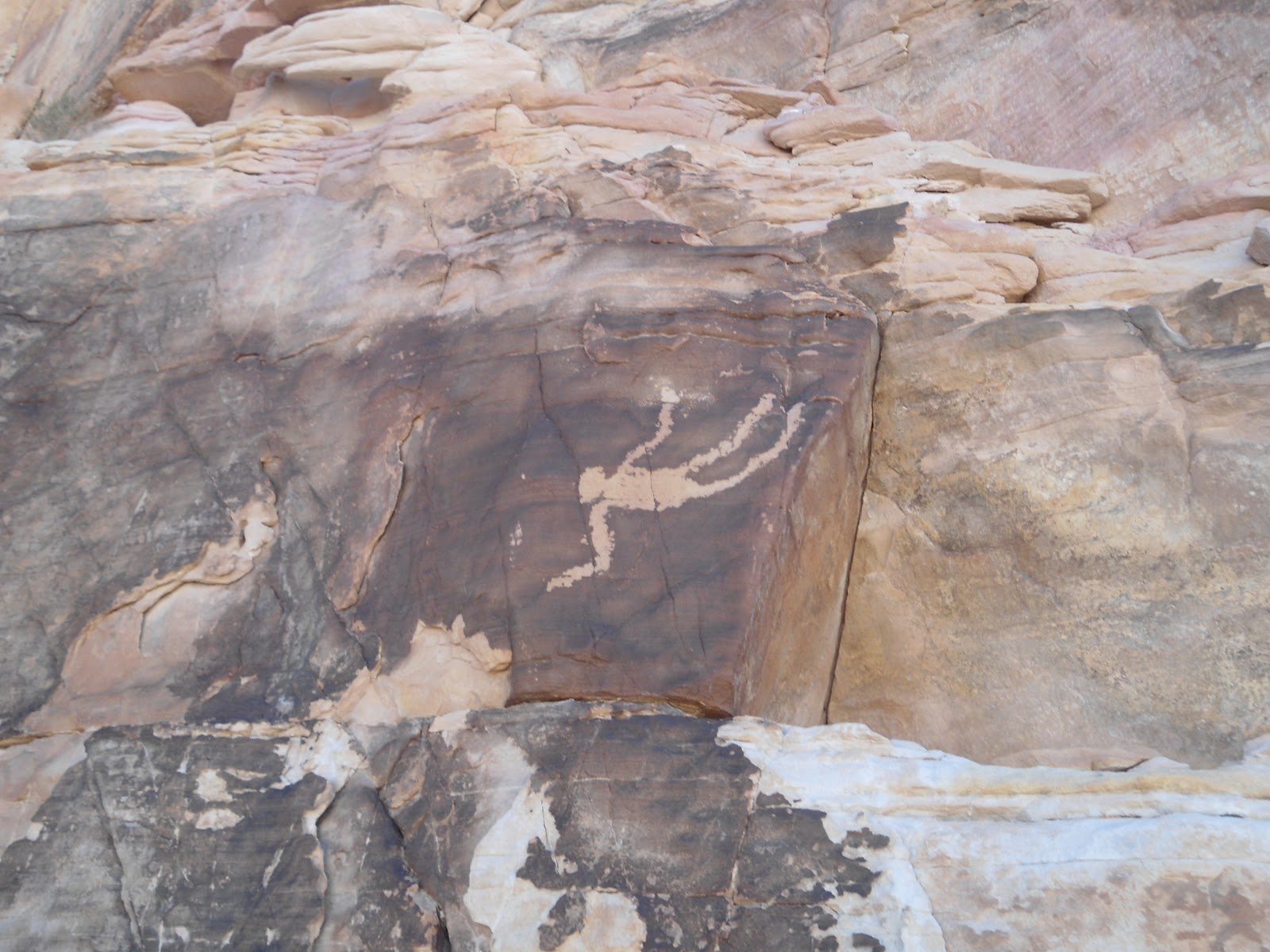
| Falling Man |
Once through the window, follow the narrow ledge to the left and see if you can spot the Falling Man petroglyph about 8 feet up on the wall by the ledge that you're on. It's not extremely large - maybe about a foot or so long - but it is very distinct. There are no other petroglyphs in the immediate area surrounding the Falling Man, but if you continue scrambling down for a few hundred yards and then head left up a small side canyon, you'll find the best panel of petroglyphs in the area. They are high up on the rock ledge - actually there are 3 different levels of the ledge that they're on. We found a way to hike up to them all.
There are probably plenty of petroglyphs that we missed, but we were happy to see what we did. Part of the fun of being there was just imagining how the early people used to live in the very area that we were exploring. We tried to imagine what plants they lived off of, what animals they ate, where they slept, etc. It was a great experience. Our total hiking distance was minimal - maybe 2 miles at most, with a little easy scrambling/climbing that just about anyone could do.
 |
| This is where it gets hard to figure out where to go. I'm at the portion of the main trail that seemingly ends in a cul-de-sac fashion. In the picture, I am pointing the way to go to get to the window. |
 |
| The faint trail that leads up to the window that you have to pass through to see Falling Man and the main panel of petroglyphs. |
 |
| Climbing up to get to the main panel of petroglyphs. |
 |
| The lower level of petroglyphs. |
 |
| Me at the first (lower) level of petroglyphs. |
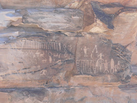 |
| Second level of petroglyphs. |
 |
| Liz at the second level of petroglyphs. |
 |
| The third level of petroglyphs, higher up on the wall. |
 |
| Let the exploring begin! |
 |
| Exploring on the top of the rock formation. |
 |
A picture of what the trail looks like just after passing through the gap in the fence.
|


No comments:
Post a Comment