Monday, August 27, 2007

Superior & Monte Cristo, elev 11040' & 11132'

With my wife still in California, I have a lot more time to go hiking. Just a few days since my assault on Red Baldy, I thought I better get another 1 - or 2 - down. I couldn’t get anyone to go with me for this hike, so I was on my own.

Having never looked for the Cardiff Pass trail head before, it took me a little time to figure out where to start from. One book I have said to park just East of the Alta Fire Station and to walk down .1 of a mile to a paved road where the trail starts. I did this, but there was no paved road after .1 or .2 of a mile. I tried to get information by stopping in the information center (located on the east side of the fire station) but they couldn’t help.

Finally I decided to continue walking down the main road and after about .26 of a mile I came to a paved road that came in from the north. I figured out that I think the Alta Fire Station the book was referring to was the old fire station because there looked to be an old fire station looking building where the road came in. For future reference, park next to the Mile post 12 sign and walk down the road for about .1 of a mile until you see the paved road come in from the north.

The paved road splits - take the road that heads right (or east), as the left fork goes to a house. The paved road winds around a building and turns into a dirt road. The dirt road switches back again and then an ATV road comes in from the left (the main dirt road continues straight). Take the ATV track to the left.

At about 9000 feet, a trail breaks off the ATV road. Take it. The trail will eventually reconnect with the road (not sure if it’s the same one) which you will once again follow until about 9300 feet. This is where a trail again breaks off from the main road on the left (north). The trail heads north about 10 yards, then crosses the road you were just on because the road switched back, and then continues on the other side of the road. The trail heads parallel to the power lines overhead but stays to the south of them at first.

The trail climbs at a steeper grade here and after a little while splits. Both ways end up at the same place so it really doesn’t matter which one you take. They both take you to a pretty little meadow with small pine forests mixed in. From here, if you look up to the ridge, you can see a power pole on top of the ridge. This is Cardiff Pass - what we are aiming for.

Once on top of the ridge at about 10,000 feet, turn left (west) and start for Superior first. The first big summit you see (which has some sort of weather station on it) is most easily bypassed on the north side, although a faint trail also leads around the south side towards a cave. I took the south route on the way up and the north (recommended) route on the way back.

Once past this summit, the trail stays for the most part on the south side of the ridge, sometimes 50-100 feet below it. I made the mistake of staying too close to the ridge which made the going harder and in some places more technical than I was comfortable with.

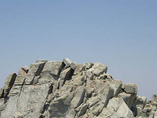
You’ll bypass another minor summit on the south and then come to a small spur ridge (barely noticeable) off of Superior’s south east side. The final 400 or so feet to the top are Class 3, sometimes maybe low class 4 due to poor route finding (personal experience). Before I started the climb, I left my trekking poles so I could use my hands for hand holds on some of the more difficult spots.

I came upon Superior’s summit much faster than I expected and looked over toward Monte Cristo and the large Cairn that marks it’s summit. The ridge between Superior and Monte Cristo is much easier than the ridge you have to negotiate before Superior.

The route is obvious, but you start by descending about 50 feet or so, continuing on towards Monte Cristo on level ground - at one point even coming to a pretty little grassy area which was a very welcome sight since all I had been hiking on for a while was rocks - and then finally coming to the final climb.

The final climb is relatively tame. It is about a 60 foot climb which was easier than most of the stuff I had already done.

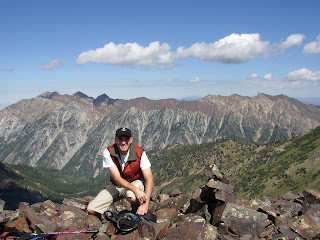
I reached the summit and enjoyed the views of the many peaks on the ridge to the south. Also beautiful was the wilderness down to the north of the peak. I have never ventured into that area yet, but pan to do so next year.

After snapping some pictures, eating some crackers and calling my wife, I headed back down because some afternoon thunderstorms looked like they were starting to develop. On my way back to Superior, I spotted a hiker coming up to Superior from the South ridge. We talked briefly on Superior’s summit. He said that it was class 4 or 5, which is a bit out of my league at the moment. He left the summit for Monte Cristo, and I headed back down also.

Not long after I left Superior’s summit, I saw a small brown fox running from the trail down into some small pine trees. Other than one very sketchy spot that required a class 4 move, the descent went good and I was back to the car much faster than it took me to go up.

This hike, although not nearly as physically demanding as Box Elder or Lone Peak’s south summit, was way more technically challenging. It is definitely not for those scared of heights as much of the trail is narrow while hugging a big rock on one side with not much but air on the other.

In total, the hike was 5.5 miles and took me 4 hours and 20 minutes to complete.

Thursday, August 23, 2007

Red Baldy, elev 11171

Another day off from work, another hike. A friend of mine, Trevor, agreed to go with me. Because this was his first hike of the year and his first "Elevener" I thought I better make it one on the easier side of the scale. Little did I know, the information I had on the Red Baldy hike was a little off.

We arrived at the White Pine trail head up the Little Cottonwood Canyon at about 8:00 and started down the trail about 8:05. I had hiked the first mile of the hike only a little over a week earlier on my way up to Red Pine lake and Pfeifferhorn.

Once we arrived at the split in the trail (straight ahead leads to Red pine Lake and left to White Pine lake), we followed the trail which makes a sharp switchback to the left. It appeared that there used to be a sign here as witnessed by a log post sticking up out of the ground with a notch for a sign. But no sign was present. The first part of the trail heads in an easterly direction and follows an old mining road.

The road switches back through Pine forests, meadows, and boulder fields, and crosses a few streams, some of which run down the road for a few yards.

After about 4 miles and walking thought a large boulder field at 10,000 feet, you leave the road and route find the rest of the way up to a spur ridge that runs up to the main ridge. One marking that helps know where to turn off is an overgrown road that breaks off briefly on the left and switches back until it ends not far after it begun into a small drainage.

You actually want to start up the drainage and, once past a steeper section off to the left, you want to head left, aiming for the last bunch of trees way up near the Red Baldy ridge. This last part of the hike is considerably more steep, covering 1100 feet in about a half a mile. Once there, it’s a short hike over stable black rocks to the summit.

We made it to the summit at about 11:20 (including an accidental .5 mile excursion to White Pine lake. Note: if you can see the lake from the road, you’ve gone too far. You won’t see it until you’ve started the final ascent up the drainage).

After a few pictures, a couple of granola bars, and a total of 30 minutes taking in the views, we decided to head back down. We made it back to the car about 2:15 just as some afternoon storm clouds appeared to be blowing in.

It was a challenging hike that had pretty scenery and a somewhat challenging final ascent to the summit. In total, it was 10.3 miles and took us 6 hours and 17 minutes to complete.

Saturday, August 11, 2007

Pfeifferhorn, elev 11326'

Another day off, another hike attempt. After trying to get a couple of people to go with me to no avail, I decided to make the attempt on my own.

I arrived at the parking lot for the White Pine trail head at about 7:45am and was on my way by 7:55am. The trail begins by descending on a paved path down to the river. A bridge crosses the river and the trail then heads off to the right (west). The first mile of the hike is a very gentile grade. It is at this point that the White Pine trail breaks off to the left, while the Red Pine trail continues straight to cross the river and a couple of other footbridges.

Not long after crossing the river the trail heads west parallel to the Little Cottonwood road far below. At one point, there is a great view down the canyon and out into the Salt Lake valley. Soon after the view of the valley, the grade steepens, but still not to drastically. The Maybird Gulch trail comes in on the right and is very noticeable due to the footbridge used to cross the river to take it. Continue straight.

A few tenths of a mile after the Maybird Gulch junction, I saw about 5 deer that didn’t seem to be afraid of me at all. One walked up to about 10 feet away from me and I was able to reach in my fanny pack, grab my camera, and snap a shot with out him even flinching.

I finally reached the Beautiful Red Pine Lake about 3.5 miles from the trail head. It was the first time I had been there, and I was enamored by the beauty of it. The Trail up to the Lake is very well kept and extremely easy to follow.

Once arriving at the lake look at the ridge behind it - This is the ridge you will need to climb to reach Pfeifferhorn’s main ridge. From the Lake, there is a well defined trail around it’s eastern side. Take it until you come to a stream that feeds into the lake. Here, the trail (or what trail there is) heads up the ridge. Although there might not be much of a trail from here to the main ridge, the rout is obvious.

The faint trail generally stays in the pine trees and heads in a south westerly direction up to the main ridge. Eventually, the trail emerges above the pine trees and from here, a little boulder hopping/climbing begins, not to mention that it was also the first time I noticed upper Red Pine Lake behind me. This was the first part of the hike that I felt my legs getting tired. The grade is steep.

Once to the main ridge, Pfeifferhorn is off to the right. A visible trail starts off to the south (left) of the main ridge as you pass a couple of minor summits before reaching the Pfeifferhorn summit base. The summit base is a massive structure which looks way too steep to hike when looking at it from a few hundred feet away. Although it is steep, it is very doable and is about as steep as the Provo Peak trail.

But first you must negotiate the "knife ridge." It really isn’t too scary unless you’re scared of heights, I guess. There is some exposure but even if you choose a poor route along the ridge (which I did a couple of times) there are plenty of big foot and hand holds to get you back to where you need to be, if you don’t just want to retrace your steps to find an easier route.
I cached my trekking poles in some bushes before starting the knife ridge so I could have my hands free for climbing (I already has mu hat fastened to my camelback due to the strong winds).

Once past the knife ridge, the steep climbing begins on the summit base. It is either a difficult class 2 or an easy class 3 climb, depending on if you use your hands for balance and the occasional pull up as much as I did.

It was a busy day on the trail and I passed a couple on their way up to the summit and was on the heels of another climber. I made it to the summit just a few minutes past 10:30am. Once on the summit I struck up a conversation with the hiker who made it ahead of me named Christian. He mentioned that it was his first time up there and that he was going to try to take the Maybird Gulch way out.

To do so, it would be a steep down climb from a spot on the knife ridge, but I watched him do it with relative ease. I’m just not sure where to pick up the trail once in the canyon.

I spent about 30 minutes on the ridge, taking pictures, eating a couple of granola bars, and just taking in the breathtaking scenery around me. The summit of the Pfeifferhorn allows for great views of so many dominant peaks in the surrounding area. It was rather cold on the summit because of the wind so I was glad I had brought some thermal sleeves to put over my arms.
The hike down was quick and I noticed a few bits of the beautiful scenery around me that I hadn’t seen on the way up. This was probably the most scenic hike I’ve been on with Timpanogos (via Aspen Grove) being a close second. It was definitely the most enjoyable hike I’ve had.

Over all, the hike was about 9.6 miles round trip and took me 5 hours and 19 minutes to complete, with 30 minutes of that resting on the summit.

Monday, July 9, 2007

South Lone Peak, elev 11230'

A day off from work meant my first attempt at a hike in almost a month. And this time I wanted to try Lone Peak via School House Springs. I scouted out this trail last fall, making it just past the second hamangog (meadow). I arrived at the trail head in the city of Alpine at 7:45 and was on my way a couple of minutes after that.

The trail begins basically right next to a house with a small makeshift parking area for maybe four cars. The trail follows a four wheel drive road and is very easy going for the first 2.9 miles to the first hamongog, with one exception. There is one spot where the road forks - what looks to be a road comes in from the left which looks like another switch back. In a few yards, this way narrows and it becomes obvious that it is not the 4-wheel drive road that you should be on. But to save a few extra unneeded steps, when the trail forks, stay straight.

The books I have mention that at a point in the four wheel drive trail (at the fifth switchback), you take a route north (straight ahead) called the "Lone Peak Trail" instead of switching back and following the road to avoid private property. Based on my previous experience where I took the Lone Peak Trail on the decent, I ended up hiking through the private property on the way up and down because the Lone Peak Trail is brutally steep and only saves .07 of a mile each way.
Once arriving at the first hamongog, a sign marks the Lone Peak Wilderness and the four wheel drive road ends. In the middle of the meadow, a sign marks trail 200 which continues on to the second hamongog. At this point, a trail also comes in from the right (east) and heads, I’m told, to lake Hardy and South Thunder Mountain.

The trail to the second hamangog actually heads in a south westerly direction at first, and I wondered last fall if I was on the right trail. Eventually, it turns back north, giving you a great view of Utah county for much of the way to the second hamongog. About halfway in between the two meadows there is a camp site which looks to be often used. From the first hamongog, it took me about 1.4 miles to reach the second hamongog.

Almost completely across the meadow is a sign marking the way to Lake Hardy via a trail that comes in from the right (east). It says that it is two miles to reach the lake. I’ve read that it is better to take this junction to get to lake Hardy instead of the one from the first hamongog, but it seems as though it would add a couple of miles to the trip.

To reach Lone Peak, continue straight, or north, right at Lone Peak. .22 miles after leaving the second hamangog, a faint trail comes in from the right which can be easily missed. This trail heads in the most direct way up to Lone Peak. From what I’ve read and been told, you can continue on the main trail (west) and reach Lone Peak from the North but this adds a few miles to the trip. If you want to reach Lone Peak from the south, heading to the south summit before attempting the true summit, take the faint trail that comes in from the north.

From this trail, the climbing begins. The trail starts off docile enough but soon the trail fades and it is just a matter of ascending drainage’s and/or climbing over slabs of granite and boulders. This was easily the toughest part of the hike and I had to take many rest stops because of the steepness of the way. It didn’t help matters either that the air was filled with smoke due to the Milford Flat fire (the biggest wild fire in the state of Utah to date). One key here that kept me going in the right direction was once to the drainage, there will be a large cliff band to your right (east) and a smaller cliff band (more like a ridge) to your left (west). At first, you’ll stay close to the small cliff band to your left, but as soon as you get out of the drainage area, you’ll want to make your way to the top of the large cliff band on your right. It is just north of the large cliff band where you’ll make your way to the ridge.

Once near the top of the large cliff band that was on your right, head in a northerly direction towards the ridge. There are two cairns that mark the spot on the ridge. Just before the ridge, I carabined my trekking poles to my camelback as a short class 3 section began. After the short class 3 climbing, it is only a short class 2 hike over tundra and small granite rocks to reach the base of the summit to South Lone Peak. Here again, there is another bit of easy class 3 climbing to reach the summit of South Lone Peak at 11,200 feet.

There is a few hundred feet between the South Summit and the true summit. The whole way is class 3 with maybe a few class 4 moves also. If you are a little fearful of heights or not much of a risk taker, the south summit would be a great ending point. If you’re up for a thrill and have enough energy left, the main summit is attainable. I down climbed to the saddle of the granite blocks between the two summits but was about out of gas. I looked to see where my next move would be and saw I would have to down climb to some dirt below and then climb steeply up to reach the main summit. The climbing looked much more vertical than I had done thus far and because I was not in great shape yet for the season, I decided to head back to the south summit and call it a day.

For me one of the hardest parts of the class 3 climbing was remembering the way I had come so I could return the same way. A couple times I had to backtrack because I had gone the wrong way and taken my self to a sheer cliff.

The way back down was as planned and I made good time. Descending the drainage in parts was actually harder than ascending it because of how steep it was. And after my boots got a little mud on them, hiking down the slabs of granite was nearly impossible with out slipping.

I made it back to the car at 3:00. The whole trip took me 7 hours and 10 minutes and registered 11.8 miles on my GPS. I think the next time I try Lone Peak, I will try it from the Cherry Canyon trail.